
On this page
On a summer afternoon you might see fat white heaps over the city. On a damp winter morning there is often a flat grey lid instead, and on a clear day, thin white streaks very high up. Each shape is a record of how the air moved. Strong, narrow updrafts pile cloud upward. Slow, wide lifting spreads it sideways. Freezing air high up makes fine threads of ice.
Why are some clouds puffy like cotton and others flat like sheets?
The World Meteorological Organization's International Cloud Atlas recognises ten cloud genera, from cirrus to cumulonimbus. Most of their names build on the categories Luke Howard set out in 1803 (cirrus, cumulus, stratus and nimbus), as NOAA's JetStream guide to the four core cloud types explains. We tell his story in Luke Howard and the Latin names we still give to clouds.
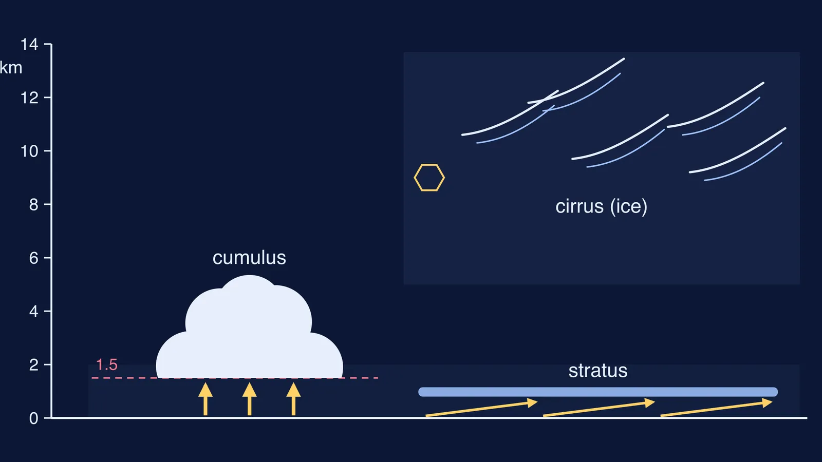
Cumulus (heap): the Atlas describes cumulus as clouds "developing vertically in the form of rising mounds, domes or towers", often like a cauliflower. NOAA says cumulus forms "show vertical motion or thermal uplift of air".
Stratus (layer): stratus is a "generally grey cloud layer with a fairly uniform base". NOAA says strato-forms "result from non-convective rising air".
Cirrus (curl of hair): cirrus are "white, delicate filaments" with a fibrous, hair-like look, and NOAA notes that cirro-forms are made of ice crystals.
So the shape tells you about the lift. In convection, sun-warmed ground heats bubbles of air that rise on their own, so the cloud grows upward in lumps above each bubble. When a whole layer of air is pushed up gently and evenly, cloud forms across a wide area at once, and you get a sheet.
What makes rising air turn into a cloud?
"As a block of air (a 'parcel') rises, it expands due to the lower pressure higher in the atmosphere. This expansion results in cooling," says NOAA's page on how clouds form.
Rising air that has not yet formed cloud cools at about 9.8 °C per km, according to the Royal Meteorological Society. The amount of water vapour in the parcel stays the same, so as it cools it eventually holds more vapour than it can at that temperature. That temperature is the dew point. Below it, vapour condenses onto tiny particles, which NOAA says need a radius of at least one micrometre, and the droplets become visible. Why they stay up is explained in why clouds float if they are made of water.
How high is the flat bottom of a cumulus cloud?
The Atlas notes that the base of a cumulus is "relatively dark and nearly horizontal". That flat floor is the height where rising air first reaches its dew point. A course page from the University of British Columbia gives a rule of thumb: cloud base height = 0.125 km per °C × (air temperature − dew point). It works for cumulus-type clouds but not for layer clouds like stratus.
Worked example, with numbers you could read off a weather app:
Pre-monsoon afternoon in Pune, say: air 34 °C, dew point 22 °C.
Gap: 34 − 22 = 12 °C.
Cloud base: 0.125 × 12 = 1.5 km.
Humid monsoon morning: air 30 °C, dew point 28 °C. Gap 2 °C, so the base is only about 250 m up. The smaller the gap, the lower the cloud.
We work through the same rule in more detail in predicting the cloud base with the 125-metre rule.
Why are cirrus clouds thin and wispy?
In temperate regions, high clouds sit between 16,500 and 45,000 feet (about 5 to 14 km), according to NOAA's JetStream guide. Up there it is very cold. Cloud physicists at the University of Manchester note that cirrus typically form below −40 °C and consist entirely of ice particles. Mid-level clouds typically form between 0 and −40 °C, so they can hold supercooled water droplets as well as ice.
That helps explain why cirrus look fibrous and silky rather than dense and sharp-edged: a wispy cloud tells you about temperature as much as about lift.
How can you read cloud shapes on your way to school?
Use this four-step check the next time you look up:
Separate heaps with flat bottoms? Convection: warm ground is sending up bubbles of air.
An even grey sheet with a uniform base? Gentle, widespread lifting of a whole layer, not bubbles.
Thin white streaks very high up? Ice. The air there is far below freezing.
Estimate the base. Take temperature minus dew point from a weather app and multiply by 125 m, using the UBC cloud-base rule of thumb. Check it against what you see.
If picturing a parcel of air cooling as it rises is the hard part, the Fermi Simulation Lab has interactive simulations for ideas that are easier to see than to read. For dew point, condensation and latent heat on their own, the Fermi Concept Library gives every concept in physics and chemistry its own lesson.