On this page
Resources and Development opens Class 10 geography and rewards exact lists and numbers. Everything below comes from the current NCERT chapter (Reprint 2026-27), so you can check any line against your book.
What is a resource, and how are resources classified?
NCERT defines a resource as anything in our environment that can satisfy our needs, provided it is technologically accessible, economically feasible and culturally acceptable (NCERT, Chapter 1).
Resources are classified in four ways:
Origin: biotic (living) and abiotic (non-living).
Exhaustibility: renewable (wind, water, forests) and non-renewable (fossil fuels, metals).
Ownership: individual, community, national and international.
Status of development: potential, developed, stock and reserves.
The chapter also defines sustainable development as development that does not damage the environment and does not compromise the needs of future generations. It names the 1992 Earth Summit in Rio de Janeiro, where more than 100 heads of state met and adopted Agenda 21.
How is land used in India?
India's relief splits roughly into plains (about 43% of the land area), mountains (30%) and plateaus (about 27%), according to NCERT's Fig. 1.3. India's total geographical area is 3.28 million sq km, but land use data are available for only 93% of it.
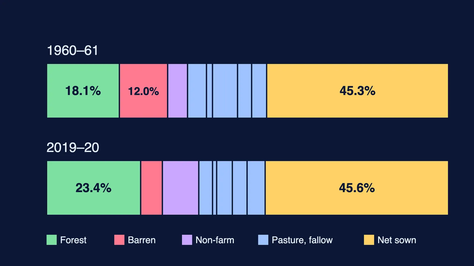
NCERT's land use pie charts (Ministry of Agriculture data) compare 1960-61 with 2019-20:
Net sown area moved only from 45.26% to 45.64% of the reporting area.
Forest grew from 18.11% to 23.41%, still far below the 33% of geographical area recommended by the National Forest Policy of 1952.
Barren and unculturable waste land fell from 12.01% to 5.40%, while area under non-agricultural uses rose from 4.95% to 9.06%.
Net sown area is the land on which crops are sown and harvested; area sown more than once in a year plus net sown area is the gross cropped area. Net sown area is over 80% of total area in Punjab and Haryana and under 10% in Arunachal Pradesh, Mizoram, Manipur and the Andaman and Nicobar Islands.
Causes of land degradation: deforestation due to mining in Jharkhand, Chhattisgarh, Madhya Pradesh and Odisha; overgrazing in Gujarat, Rajasthan, Madhya Pradesh and Maharashtra; and over-irrigation (waterlogging, then salinity and alkalinity) in Punjab, Haryana and western Uttar Pradesh.
What are the main soil types of India?
NCERT's map shows six groups. Learn each as soil, where, and one feature, from the chapter:
Alluvial: northern plains and eastern deltas of the Mahanadi, Godavari, Krishna and Kaveri; very fertile; old alluvium is bangar, new is khadar.
Black (regur): Deccan trap region of Maharashtra, Saurashtra, Malwa, Madhya Pradesh and Chhattisgarh; holds moisture; ideal for cotton.
Red and yellow: crystalline igneous rocks of the eastern and southern Deccan; red from iron, yellow when hydrated.
Laterite: areas of heavy rain and intense leaching; acidic (pH below 6.0); tea and coffee after soil conservation in the hills of Karnataka, Kerala and Tamil Nadu; cashew on red laterite soils.
Arid: sandy and saline; kankar in lower layers; cultivable after irrigation, as in western Rajasthan.
Forest: hilly and mountainous areas; acidic with low humus in snowy Himalayan areas.
For the reason black soil and cotton go together, read our explainer on why black soil suits cotton.
How can soil erosion be prevented?
Soil erosion is the removal of the soil cover and its washing down; the chapter names gullies, bad land (ravines in the Chambal basin), sheet erosion and wind erosion (NCERT). Match each method to its landscape:
Hill slopes: contour ploughing and terrace farming (well developed in the western and central Himalayas).
Large flat fields: strip cropping, with grass between crops to break the wind.
Deserts: shelter belts of trees, which have helped stabilise sand dunes in western India.
The Dust Bowl in the United States shows what wind erosion does at scale, and crop rotation with legumes is another way farmers keep soil productive.
How should you answer questions on this chapter?
A worked 30-word answer to the textbook question on soil in the eastern deltas:
*Alluvial soil is found in the deltas of the Mahanadi, Godavari, Krishna and Kaveri. It is very fertile, has adequate potash, phosphoric acid and lime, and suits paddy and sugarcane.*
That answer names the soil, the place and three features; use this pattern for every short answer.
A five-day revision plan:
Day 1: the four classifications, with two examples each, from memory.
Day 2: land use figures for 1960-61 and 2019-20; explain why forest has grown slowly.
Day 3: draw India's soil map freehand and mark the six types.
Day 4: link each degradation cause to its states and each conservation method to its landscape.
Day 5: answer the chapter's exercises against the clock, then check against the text.
If you get stuck on what to revise next, Fermi's AI tutor can work out what you already know and build a plan for the session, so you sit down to a clear next step.