On this page
Stand on the Amarkantak plateau in Madhya Pradesh and you are near the source of two rivers that part ways. The Son runs north and then east to join the Ganga. The Narmada heads west for the Arabian Sea. The big rivers of the southern plateau, such as the Godavari, the Krishna and the Kaveri, end in the Bay of Bengal instead. The difference comes down to a crack in the Earth's crust.
Why do most peninsular rivers flow east?
The NCERT Class 11 textbook India: Physical Environment, chapter 3 (Drainage System) gives two reasons. First, the Western Ghats run close to the west coast and act as the water divide between the major peninsular rivers. Second, a slight tilting of the Peninsular block from north-west to south-east turned the whole drainage system towards the Bay of Bengal.
Nearly 77 per cent of India's drainage area drains towards the Bay of Bengal and 23 per cent towards the Arabian Sea, according to the same NCERT chapter. It names the high ground between the two as the Delhi ridge, the Aravalis and the Sahyadris; for the story of one of them, read why the Aravalli hills are India's oldest fold mountains.
Why does the Narmada flow west through a rift valley?
Start with the word fault. NCERT defines a fault as a sharp break in the crustal rocks, along which rocks tend to move in opposite directions.
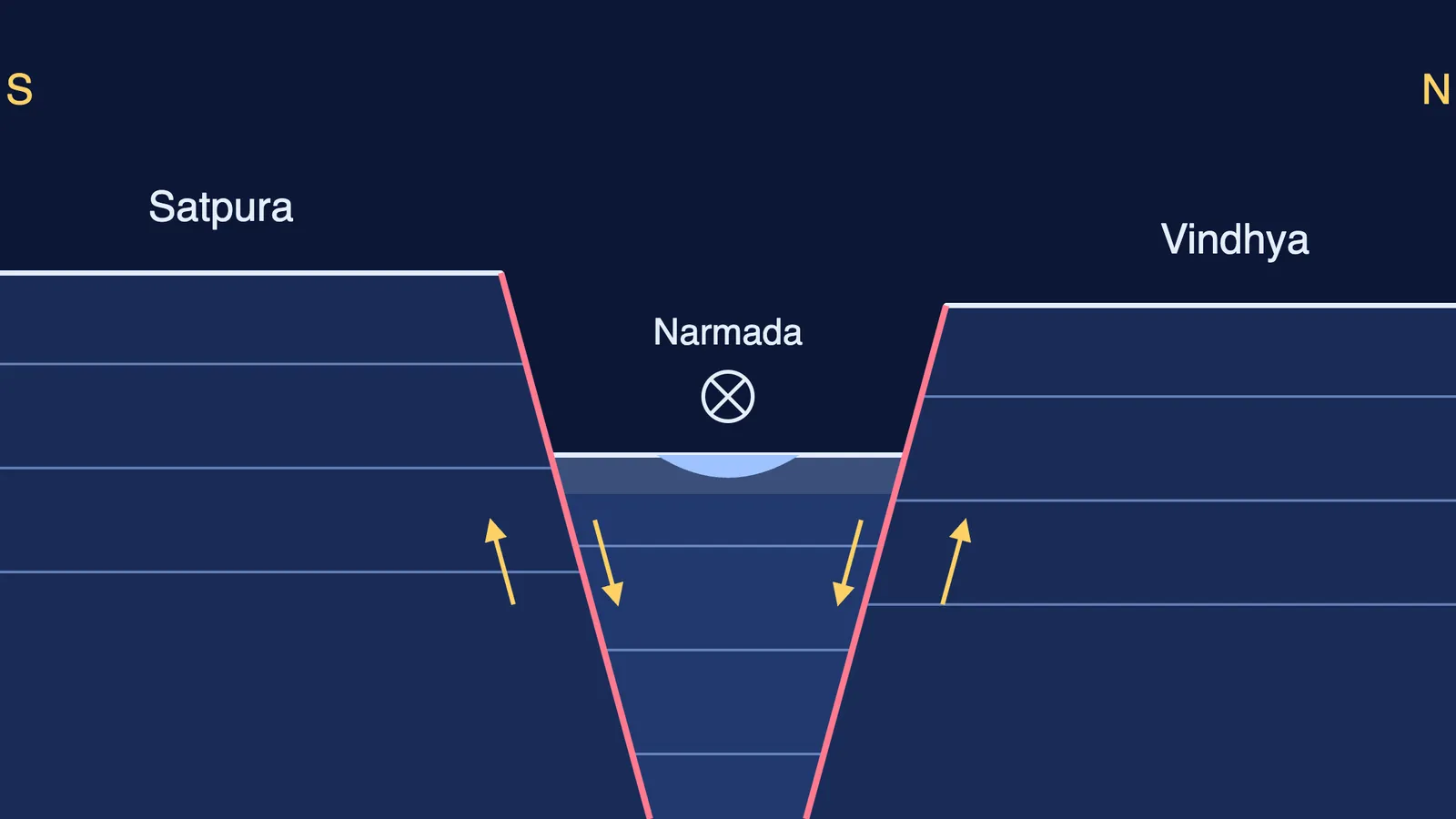
When the Himalayas rose, the northern flank of the Peninsular block sank and was broken by trough faulting, the Class 11 drainage chapter explains. A strip of crust dropped between faults, leaving a long, narrow trough: a rift valley. The Narmada and the Tapi flow in these trough faults.
So the Narmada did not cut its own path to the sea. It took over a trough that was already there, between the Vindhyan range to the north and the Satpura range to the south. Water follows the lowest ground, and this trough leads west to the Arabian Sea, so the river does too.
The NCERT chapter traces the route. The Narmada rises on the western flank of the Amarkantak plateau at about 1,057 m. Near Jabalpur it forms a gorge in marble rocks and the Dhuandhar waterfall. After about 1,312 km it meets the Arabian Sea south of Bharuch. The Tapi, its smaller neighbour, rises at Multai in Betul district and is 724 km long.
Why does the Narmada form an estuary instead of a delta?
The Narmada and the Tapi fill the original cracks with the material they carry, so they lack alluvial and deltaic deposits, NCERT notes. The Narmada ends in a broad estuary about 27 km long. The Godavari, by contrast, splits into several branches after Rajamundri and forms a large delta.
Peninsular rivers also keep a fixed course and do not meander, the same chapter says. Himalayan rivers on the plains are restless by comparison, as our explainer on why the Kosi river keeps changing its course shows.
Narmada vs Godavari: what is different?
All figures below are from the NCERT Class 11 drainage chapter.
Direction: the Narmada flows west to the Arabian Sea; the Godavari flows east to the Bay of Bengal.
Length: the Narmada is about 1,312 km long; the Godavari is 1,465 km.
Catchment: about 98,796 sq km for the Narmada; over 3.13 lakh sq km for the Godavari.
Valley: the Narmada runs in a rift valley; peninsular rivers like the Godavari mostly run in broad, shallow, graded valleys.
Mouth: the Narmada has a 27 km estuary; the Godavari has a large delta.
How do you answer this in an exam?
Use this five-step plan, one sentence per step.
Rule: most peninsular rivers flow east because the Western Ghats form the water divide and the block tilts from north-west to south-east.
Exception: the Narmada and the Tapi flow west into the Arabian Sea.
Cause: they flow in rift valleys formed by trough faulting when the northern flank of the Peninsular block subsided.
Location: the Narmada's rift valley lies between the Vindhyan range to the north and the Satpura range to the south.
Result: little deltaic deposit, so the river ends in an estuary.
Then test yourself in two minutes. Close the book and sketch a north-south cross-section like the diagram at the top of this page: two high blocks, two faults, and the river in the dropped block between them. If you can label the Satpura and Vindhya sides correctly, you have it.
If a picture works better for you than a paragraph, Fermi's AI tutor works out what you already know, builds a plan for the session and draws the figure as it teaches, checking your understanding as it goes.
Much of the Maharashtra plateau, south of the Narmada, is covered by old lava flows called the Deccan Traps, NCERT notes. Read next: what the Deccan Traps are, and what they had to do with the dinosaurs.