
On this page
Every few decades the Kosi, which flows out of Nepal into north Bihar, leaves its channel and takes a new path across the plains. It is the erosion-and-deposition story from your geography syllabus, at a scale big enough to move a river by tens of kilometres.
Why does the Kosi river keep changing its course?
Rajiv Sinha of IIT Kanpur, writing in Current Science in 2009, notes that the Kosi's mountain catchment is 5.3 times the size of the alluvial area where it reaches the plains. A huge area erodes; a small area has to receive it.
About 100 million tonnes of sediment pass Chatara, where the Kosi leaves the hills, every year, according to a 2019 study in the Journal of Hydrology (abstract on ICIMOD's library). The same study found about 20 million tonnes deposited between Chatara and Birpur and about 53 million tonnes between Birpur and Baltara each year.
Adding the two (our arithmetic), roughly 73 million tonnes a year, close to three-quarters of the load measured at Chatara, settles on the plains between Chatara and Baltara instead of travelling on downstream.
How does sediment lift a river above its own floodplain?
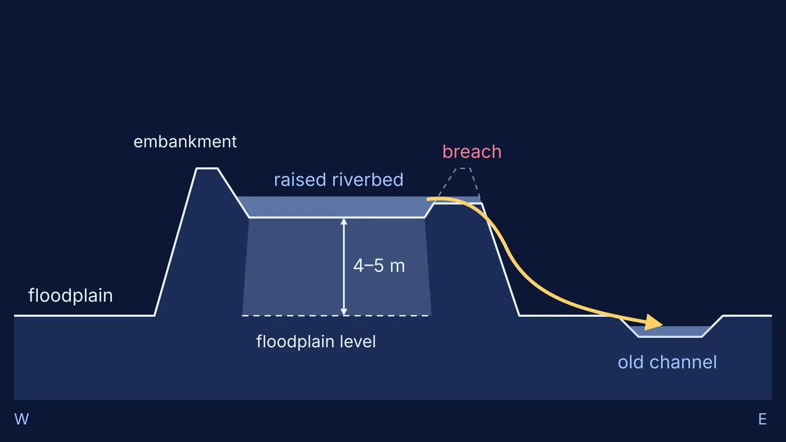
When the Kosi leaves the steep Himalaya, its slope drops sharply. Slower water carries less, so the load settles on the riverbed, and year after year the bed and banks build upward. A river whose bed and water stand higher than the land beside it is called superelevated.
A superelevated river is unstable: once a flood breaks the bank, water runs downhill into lower ground next door, often an old abandoned channel. A 2024 study in Nature by James Gearon and colleagues found that on fans near mountain fronts, where the alternative paths are about as steep as the river's own, rivers avulse when they are perched above the surrounding landscape.
The Kosi has built such a fan. Tapan Chakraborty and colleagues at the Indian Statistical Institute describe the Kosi megafan as covering more than 10,000 km² with a gradient of only 0.05° to 0.01°. On land that flat, a few metres of deposit can change which way the water wants to go.
What happened when the Kosi broke out in August 2008?
By 1956 the Kosi was embanked on both sides. According to Sinha's 2009 paper, most of the sediment was then trapped between them: near the western embankment, the riverbed was at least 4–5 m higher than the surrounding floodplain.
On 18 August 2008 the eastern embankment breached at Kusaha in Nepal, 12 km upstream of the Kosi barrage. The breach came at a discharge of 144,000 cusecs, much less than the 950,000 cusecs the barrage and embankments were designed for. Sinha argues that aggradation had pushed the river close to its avulsion threshold, so a modest flood was enough. About 80–85% of its flow went into an old channel, and he reports that more than 30 million people were affected.
NASA Earth Observatory satellite images from 24 August show the river cutting south into a channel it had abandoned more than 200 years earlier. Sinha puts the jump at about 120 km east; Chakraborty's team, measuring across the middle of the fan, at about 60 km.
Did the Kosi really march steadily west for 200 years?
Many textbooks say so, and Sinha's paper cites a westward movement of 150 km over the last 200 years. Chakraborty's team examined 28 historical maps published between 1760 and 1960 and argued instead that the channel oscillated, relocating by random avulsions rather than marching one way. An earlier study by Wells and Dorr in Geology (1987) accepted the westward trend but described each major shift as random: a channel fills until unstable, then floodwater drains into a nearby low.
How do you use the Kosi in a geography answer?
Use this five-link chain, one sentence per link:
Erosion: steep Himalayan rivers erode a large catchment and carry a heavy load.
Loss of energy: at the mountain front the gradient falls, so velocity and carrying capacity fall.
Deposition: the load settles, building an alluvial fan crossed by braided channels.
Aggradation: the bed rises until the river is superelevated above the plain beside it.
Avulsion: a flood breaches the bank and the river takes the lower path, often an old channel.
Then add one sourced fact as evidence, such as the 4–5 m bed height or the 2008 breach at well below design discharge, both from Sinha (2009).
The Fermi Simulation Lab has interactive simulations for ideas, like slope and flow, that are easier to see than to read. For a gap in the underlying physics, such as why slower water drops heavier grains, the Fermi Concept Library gives each concept its own lesson.
Next time you see photos of north Bihar under water, look for the sand. It shows where the river has been, and hints at where it may go.