
On this page
Who is Rajendra Singh and why did he start building johads?
In October 1985, an Ayurvedic doctor named Rajendra Singh arrived in the Alwar district of Rajasthan with volunteers from Tarun Bharat Sangh to establish health and literacy clinics. Local elder Mangu Lal Patel in Gopalpura redirected him immediately: poverty and disease stemmed from water scarcity. Decades of deforestation and unplanned mechanical drilling had dropped regional water tables into a government-classified "dark zone," leaving dug wells dry and agricultural fields uncultivated.
Patel told Singh to revive johads—traditional crescent-shaped earthen check dams that capture monsoon rains. Working alongside villagers with picks and shovels, Singh desilted and repaired a neglected earthen bund in Gopalpura. When seasonal rains arrived, the impounded pond filled and surrounding dry wells began recharging within months. Tarun Bharat Sangh expanded this participatory approach across eastern Rajasthan, earning Singh the Ramon Magsaysay Award in 2001 and the Stockholm Water Prize in 2015. Understanding this revival requires examining how hand pumps draw water from subterranean layers.
How does an earthen check dam recharge groundwater?
In Rajasthan, intense seasonal downpours arrive during the southwest monsoon, an atmospheric circulation driven by land-sea thermal contrasts as detailed in what causes the Indian monsoon. On dry, degraded ground, torrential rain generates rapid overland runoff that erodes fragile topsoil and escapes as destructive flash floods.
Engineering assessments documented in *Agricultural Water Management* describe how a johad alters this hydrological dynamic:
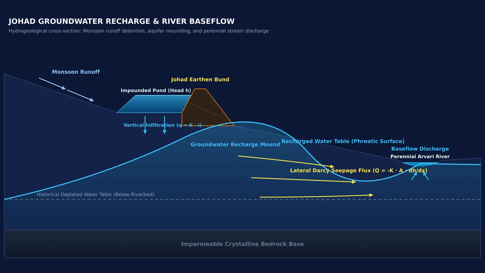
Velocity reduction: The curved earthen bund, typically built 1 to 3 metres high (with larger bandhs up to 6 metres) and side slopes of 1.5:1 to 2:1, slows runoff across a shallow catchment.
Hydrostatic head: Ponded surface water creates hydraulic head, driving vertical percolation downward through the unsaturated soil zone.
Groundwater mounding: Infiltrating water elevates the local water table, spreading laterally through permeable unconfined alluvium.
This movement follows Henry Darcy's groundwater flow law, where seepage flux scales directly with soil hydraulic conductivity and hydraulic head gradients.
How did johads turn the dry Arvari into a perennial river?
The Arvari River in Alwar had dried into an ephemeral sandbed for roughly 60 years. As highlighted by the Stockholm Water Prize, between 1987 and 1995, 72 villages built approximately 375 johads across the 476-square-kilometre catchment. In 1990, the river began flowing for several months post-monsoon; by 1995, it became perennial year-round.
This transformation occurred through baseflow reversal:
Influent phase: Depleted groundwater tables lay far beneath the channel bed, causing ephemeral surface runoff to leak downward into dry sediments and vanish.
Aquifer recharge: Concentrated percolation from hundreds of johads documented by researchers (Glendenning and Vervoort, 2010) raised water tables from depths below 40 metres to within 3 to 13 metres of the surface.
Effluent phase: Once the regional water table rose above the riverbed elevation, groundwater discharged directly into the streambed as baseflow, sustaining continuous streamflow through summer.
In 1999, local communities established the Arvari Sansad (River Parliament), detailed in the Ramon Magsaysay Award citation, uniting 72 villages to regulate baseflow by banning commercial borewells and water-intensive cash crops.
What does hydrology research show about rainwater harvesting efficiency?
To measure the physical impact of johads, hydrologists Claire J. Glendenning and R. Willem Vervoort conducted a multi-year field study in the Arvari catchment.
Their field data published in *Agricultural Water Management* quantified recharge mechanics:
Pond recharge: Potential infiltration beneath johads averaged 12 to 52 millimetres per day.
Net aquifer recharge: Water reaching the regional unconfined aquifer averaged 3 to 7 millimetres per day after meeting soil moisture deficits.
Rainfall capture: Approximately 7% of total catchment rainfall recharged into groundwater reserves.
Their companion catchment-scale modelling in *Agricultural Water Management* demonstrated that decentralized check dams buffer communities during drought years by storing water underground. However, the simulation also revealed critical hydrological trade-offs: capturing upstream runoff can reduce downstream river flow by up to 75% during dry periods, showing that check-dam density must be carefully balanced with downstream water availability.
How can students calculate aquifer recharge using Darcy's law?
Students of fluid mechanics can apply Darcy's law to model vertical percolation under a johad pond. Using hydraulic conductivity values typical of Alwar alluvium documented in *Agricultural Water Management*, consider an earthen pond with these parameters:
Pond basin area: A = 2,500 m²
Water depth (hydraulic head): h = 2.0 m
Saturated sediment thickness: L = 1.0 m
Hydraulic conductivity: K = 2.5 × 10⁻⁶ m/s (0.216 m/day)
Worked step-by-step calculation:
Determine hydraulic gradient: Total head drop across the bed is Δh = h + L = 2.0 m + 1.0 m = 3.0 m. Gradient i = Δh / L = 3.0 m / 1.0 m = 3.0.
Calculate infiltration velocity: Darcy flux q = K × i = 2.5 × 10⁻⁶ m/s × 3.0 = 7.5 × 10⁻⁶ m/s (0.648 m/day).
Compute daily volumetric recharge: Q = q × A = 0.648 m/day × 2,500 m² = 1,620 m³/day (1,620,000 litres per day).
In watershed planning, bund crests are sized to prevent overtopping, while verifying that vertical percolation outpaces open evaporation (typically 4 to 8 millimetres per day as documented in *Agricultural Water Management*).
To explore models of fluid flow in an interactive environment, visit the Fermi Simulation Lab for interactive simulations designed for ideas that are easier to see than to read. For multi-step fluid mechanics problems, the Fermi Problem Library provides worked questions with a step-by-step solver that explains the reasoning rather than printing an answer.