On this page
For centuries a ship out of sight of land could work out how far north or south it was, but not how far east or west. In 1714 Britain offered £20,000 to anyone who could find longitude at sea to within 30 nautical miles, according to the Linda Hall Library. The method that won out came from a self-taught clockmaker, John Harrison, and it rests on one idea: longitude is a difference in time.
Why does a clock give you longitude?
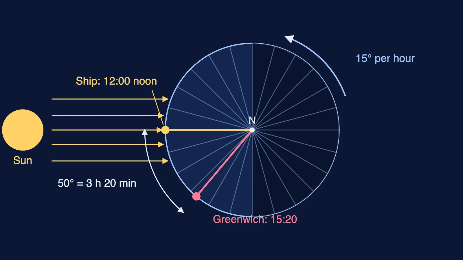
The Earth rotates through 360° in 24 hours, so one hour of time difference equals 15° of longitude (Royal Museums Greenwich). Put another way, the Earth turns through one degree of longitude every four minutes.
Local time is easy to find at sea: local noon is the moment the Sun stands highest. The hard part, as Royal Museums Greenwich explains, was knowing the time at the reference place at that same moment. Carry a clock that keeps home-port time, and the gap between it and your local noon is your longitude. If the home clock is ahead, you are west of home; if it is behind, you are east.
The catch was the clock. Rival methods read the time from the sky instead, using lunar distances (the Moon against the stars) or the moons of Jupiter (Royal Museums Greenwich). A pendulum clock needs a steady swing, which a rolling deck disturbs; even on a still bench a swing slowly dies away, as our pendulum damping practical shows.
Who was John Harrison, and what did he build?
Harrison was born on 24 March 1693 and died on his 83rd birthday in 1776 (Linda Hall Library). He was a carpenter by trade who taught himself clockmaking. Royal Museums Greenwich traces his sea timekeepers:
H1 was tested on a voyage to Lisbon in 1736.
H2 was finished but never went to trial.
H3 was begun in 1740.
H4 used a new type of balance from a watch Harrison commissioned around 1751-52. Its large balance ticks five times a second.
How accurate was Harrison's H4 at sea?
In 1761 H4 sailed for Jamaica with Harrison's son in charge. It arrived two months later only 5 seconds slow, and on a second voyage in 1764 it gave longitude to within 10 miles (Linda Hall Library).
What do 5 seconds mean? Four minutes is one degree, so 5 seconds is 5/240 of a degree, or 1.25 minutes of arc. A nautical mile is one minute of latitude, exactly 1.852 km (NOAA). At the equator a minute of longitude is the same size, so the error was about 1.25 nautical miles, or 2.3 km, and a little less near Jamaica, where lines of longitude crowd together. At the equator the 1714 target of 30 nautical miles is half a degree: at most 2 minutes of clock error over the whole voyage.
The reward came slowly. The Board recommended £10,000 once Harrison showed how H4 worked, and the rest only when other makers could build similar timekeepers, terms written into the Longitude Act of 10 May 1765 (Royal Museums Greenwich). Parliament paid a final £8,750 in 1773 after an appeal to King George III, but the official prize was never awarded (Linda Hall Library).
How do you work out longitude from a clock?
Say your chronometer keeps Greenwich time and reads 15:20 when the Sun is highest.
Your local time is 12:00 noon.
The difference is 3 hours 20 minutes, or 3.33 hours.
Multiply by 15° per hour (Royal Museums Greenwich): 3.33 × 15 = 50°.
Greenwich is ahead of you, so you are at 50° W.
You can try the same rule in India. Indian Standard Time is UTC+5:30 (CSIR-National Physical Laboratory), and 5.5 hours × 15° per hour gives 82.5° E, the meridian IST is based on. With a friend in another city:
On the same sunny day, each of you sets a straight stick upright on flat ground.
Around midday, mark the shadow every few minutes and note the IST time of the shortest one.
Divide the difference in minutes by 4 to get how many degrees of longitude apart you are; the later noon is further west.
Using the same day cancels the small seasonal drift in when the Sun peaks. If a turning Earth is hard to picture, the Fermi Simulation Lab has interactive simulations for ideas that are easier to see than to read, and the Fermi Problem Library has worked problems with a step-by-step solver that explains the reasoning.
Surveyors on land had other tools: read how Kishen Singh mapped Tibet by counting his steps. Next time you see a time-zone map, read it as a longitude map.