
On this page
The toposheet question hands you a map you have never seen and asks you to read it on the spot. You cannot memorise it, but the syllabus names a short list of skills, and each has a method you can drill.
What does the ICSE toposheet question test?
The Geography paper is two hours long and carries 80 marks. It has two parts, and Part I has two compulsory questions: one on the topographical map and one on an outline map of India, according to the ICSE Class 10 geography syllabus as reproduced by ICSE Portal. The map unit, as listed on Future Topper's copy of the syllabus, covers:
locating features with four-figure or six-figure grid references
contours and landforms: steep and gentle slopes, hills, ridges, escarpments
colour tints and conventional symbols on Survey of India maps
scale (statement, representative fraction, linear scale) to measure distance and area
directions using the eight cardinal points
settlements, land use and means of transport
drainage patterns (dendritic, trellised, radial) and settlement patterns
telling natural features from man-made ones
CISCE revises its syllabus, so check the current PDF on its website first.
How do you read a six-figure grid reference?
Eastings come first, then northings. Eastings are the vertical lines, numbered along the bottom; northings are the horizontal lines, numbered up the side. One way to remember it: along the corridor, then up the stairs.
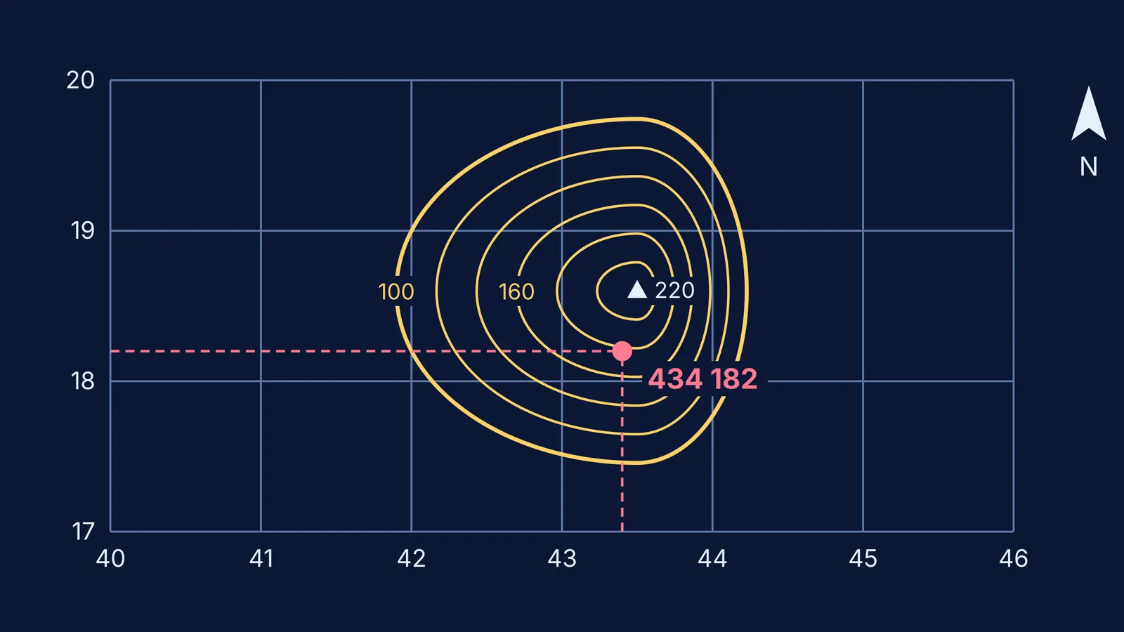
Worked example, using the diagram at the top of this post:
Find the vertical line just left of the point: 43.
Estimate how many tenths of the square the point sits to the right of that line: 4. Your easting is 434.
Find the horizontal line just below the point: 18.
Estimate the tenths above it: 2. Your northing is 182.
Write the reference as 434182. The four-figure reference of the whole square is 4318.
The two common slips are reversing the order (182434 is a different place) and naming a square by its top-left corner instead of its bottom-left.
How do you work out distance and area from the scale?
A representative fraction of 1:50,000 means 1 cm on the map is 50,000 cm on the ground, which is 0.5 km. So a straight road measuring 7.2 cm on the sheet is 7.2 × 0.5 = 3.6 km. For a curved road or river, lay a thread along it, straighten it against your ruler, then convert.
For area, use the same scale. At 1:50,000, a square 2 cm on each side is 1 km by 1 km, so it covers 1 sq km. Count the full squares, add the partly covered squares as roughly half each, and always write the unit. If the ratio arithmetic is shaky, our guide to solving map scale problems goes through it step by step. If your working in multi-step problems keeps going wrong, the Fermi Problem Library has worked problems with a step-by-step solver that explains the reasoning rather than printing an answer.
How do you read contours and landforms?
A contour is a line joining places of the same height above mean sea level. The contour interval is the height difference between two neighbouring contours, and you work it out by subtracting their labels. Then read the spacing:
lines close together mean a steep slope; lines far apart mean a gentle one
closed rings with heights rising inwards mean a hill
long, narrow rings mean a ridge
lines bunched tightly along one side suggest an escarpment or a cliff-like steep slope
a spot height is a dot with a number; a triangulated height is marked with a small triangle
In the diagram above, the rings bunch up on the east side of the hill, so that side is steeper. Relative height is the difference between two heights read off the map, such as a summit and a nearby river bed.
How should you practise map work in four weeks?
Use real sheets, not only textbook extracts. The Survey of India offers free 1:50,000 Open Series Maps as PDFs, which you can find by sheet number (the site gives 39L/12 as an example) or by choosing a state and district. Download your own district's sheet: roads and rivers you already know make your reading easier to check.
Week 1: symbols and colour tints. Cover the legend of a practice sheet, name 20 symbols from memory, then check.
Week 2: grid references and directions. Each day, write references for 10 features you pick, then find 10 features from references a friend gives you.
Week 3: scale, distance, area and contours. Measure three routes and one area each day, then describe the slope on two sides of one hill.
Week 4: full timed toposheet questions from past papers, followed by the outline map of India. Mark your answers and note which question type cost you marks.
Parents who want to help without taking over can use our guide to helping your child with map work.
Preparing for History and Civics as well? See how to prepare ICSE History and Civics.