
On this page
In the Islamic world, the person said to have built the first astrolabe, a flat brass instrument that tells the time from a star, is al-Fazari, an 8th-century astronomer at the court of the caliph al-Mansur in Baghdad. He also helped turn an Indian astronomy text into Arabic. Here is what the sources say, what is uncertain, and how to repeat the astrolabe's core measurement with a stick.
Who was al-Fazari?
Medieval biographers were unsure whether Ibrahim al-Fazari and Muhammad ibn Ibrahim al-Fazari were two people. Historian Kim Plofker's entry in the Biographical Encyclopedia of Astronomers says "not even his identity is entirely certain", and that "it is now assumed" the various references to the astronomer al-Fazari mean the same individual.
The same entry says he came from an old family of Kufa, near Najaf in modern Iraq, and worked on astronomy and astrology at the court of al-Mansur, who reigned from 754 to 775. Al-Mansur commissioned Baghdad on 30 July 762, so this was a brand-new capital. Plofker adds that "almost nothing of his own works remains with us"; we know him through later writers.
Did al-Fazari build the first astrolabe in the Islamic world?
That is the tradition, worded with care. David Pingree, writing in the Dictionary of Scientific Biography, says medieval bibliographers record books by him on the use of the plane astrolabe and the armillary sphere, and that al-Fazari "is said to have been the first in Islam to construct one". Plofker's entry lists titles, known only by name, on the use of the plane astrolabe, the armillary sphere and the measurement of noon.
No astrolabe of his survives. An astrolabe made by Nastulus and dated 927/928 "is considered the oldest surviving astrolabe" and is kept at the Kuwait Museum of Islamic Art, according to the Biographical Encyclopedia of Astronomers. So "first" here rests on written records, not on an object you can hold. Later makers went further: see how Al-Zarqali built an astrolabe that works at any latitude.
How does a plane astrolabe work?
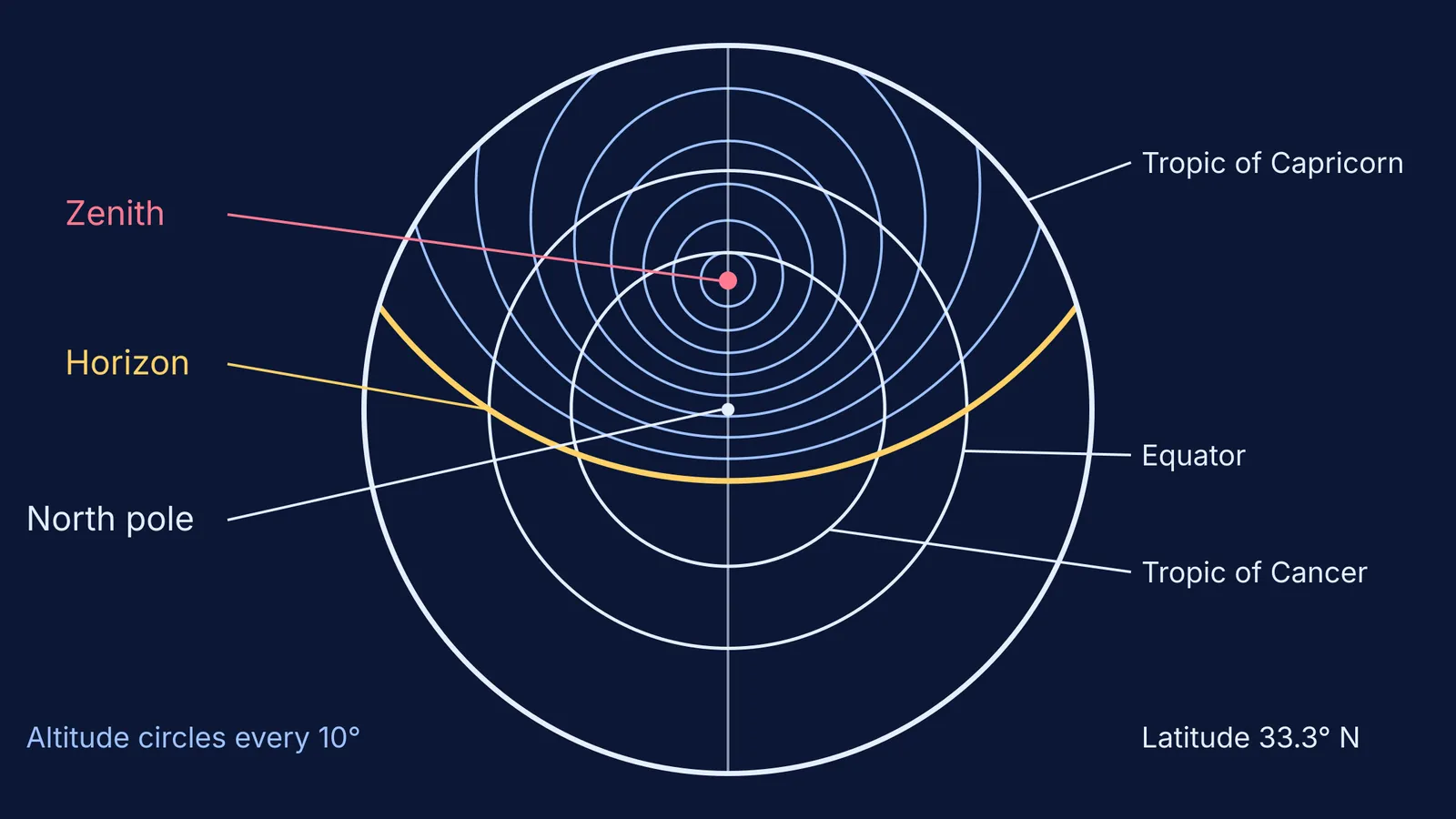
An astrolabe is a map of the sky on a flat plate. The Whipple Museum of the History of Science explains that the celestial sphere is drawn on the plate using stereographic projection, a method that turns the 3-D sphere into a 2-D drawing.
Circles on the sky stay circles on the plate, which is why the plate pictured above is all circles. The main parts:
Plate: "Each latitude needs its own projection", so astrolabes came with plates for particular latitudes.
Rete: a cut-out star map that rotates over the plate, carrying star pointers.
Alidade: a rotating bar on the back; you line up a star in its two sighting holes and read its altitude in degrees on the scale around the edge.
To tell the time, you measure a star's altitude, turn the rete until its pointer sits on that altitude circle, then use the rule to read the hour on the rim.
What Indian astronomy text did al-Fazari translate?
According to Pingree's entry, an embassy from Sind included an Indian astronomer whose identity is unknown. Al-Mansur asked al-Fazari to work with him on an Arabic translation of a Sanskrit text, apparently called the Mahasiddhanta. The embassy is dated to 771 or 773. The result, the Zij al-Sindhind, started a long tradition in Islamic astronomy.
Plofker's entry links the Sanskrit source to the tradition of Brahmagupta's 7th-century Brahmasphutasiddhanta, though the resulting tables were an "eclectic" mix that also drew on Sasanian Persian astronomy, with a little Ptolemaic influence. Some popular profiles, such as Muslim Heritage, date the translation to about 750.
Indian trigonometry travelled the same routes: see how Aryabhata's jya table became the sine.
How can you find your latitude like an astrolabe user?
A shadow can measure an altitude angle too. From the PVEducation solar guide, in the northern hemisphere with the Sun to the south: noon altitude = 90° − latitude + declination. On an equinox day in March or September the Sun's declination is close to zero, so latitude = 90° − noon altitude.
Stand a straight stick upright on level ground and measure its height.
Around local noon, mark the shadow tip every few minutes; keep the shortest.
Work out the Sun's altitude: tan(altitude) = stick height ÷ shadow length.
Subtract from 90°.
Worked example: a 1.00 m stick casts a shortest shadow of 0.53 m. Then tan(altitude) = 1.00 ÷ 0.53 = 1.887, so altitude ≈ 62.1°. Your latitude ≈ 90° − 62.1° = 27.9° N.
Never look at the Sun, even through a straw or pinhole; the shadow does the work.
If a 3-D sky on a flat plate is hard to picture, the Fermi Simulation Lab has interactive simulations for ideas that are easier to see than to read. For the tan step, the Fermi Concept Library gives each concept in mathematics its own lesson.
Try it on the next equinox and compare your answer with a map; being a degree or two off is normal.