
On this page
The Bengal Delta is the largest delta on Earth, spanning West Bengal and Bangladesh. Formed by the confluence of the Ganga, Brahmaputra, and Meghna rivers, it drains a catchment of 1.7 million square kilometres across the Himalayas and northern plains. As shown by John D. Milliman and Robert H. Meade in *The Journal of Geology* (Milliman & Meade, 1983), this system discharges more solid sediment to the ocean than any other river on Earth.
Stratigraphic budgets by Steven L. Goodbred Jr. and Steven A. Kuehl in *Geology* (Goodbred & Kuehl, 1999027<0559:HAMSBF>2.3.CO;2)) show that these rivers deliver roughly 1 billion tonnes of sediment annually to the Bengal Basin. Over the Holocene epoch, this flux built a subaerial delta plain of 110,000 square kilometres. NASA Earth Observatory imagery reveals vast sediment plumes extending hundreds of kilometres into the Bay of Bengal, feeding the mangrove islands of the Sundarbans.
Why does the Ganga-Brahmaputra form a delta?
A river forms a delta whenever sediment delivery to the coast exceeds the rate at which waves and currents disperse material into deeper water. In the Ganga-Brahmaputra basin, this balance tips decisively toward deposition. As documented in regional sedimentary budgets (Goodbred & Kuehl, 1999027<0559:HAMSBF>2.3.CO;2)), three factors align to build this landform:
Active Himalayan uplift: Tectonic collision thrusts up steep slopes, generating fractured rock and landslides that supply continuous debris.
Heavy monsoon runoff: Concentrated summer rains wash hundreds of millions of tonnes of weathered sediment into mountain tributaries.
Tectonic subsidence: The Bengal Basin steadily subsides under sediment weight, creating the accommodation space needed to trap thick sedimentary strata rather than losing them to deep ocean trenches.
How does river velocity control silt deposition?
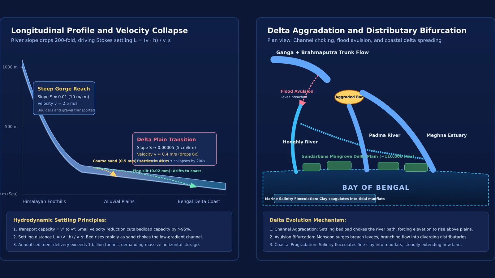
Fluvial mechanics explains why sediment drops out of the flow. In mountain gorges, steep slopes drive torrential currents carrying coarse gravel and sand as bedload. However, as geological measurements show (Goodbred & Kuehl, 1999027<0559:HAMSBF>2.3.CO;2)), channel slope in the lower Bengal Basin drops below 10 centimetres per kilometre. Because shear stress scales directly with slope, flow velocity plunges near sea level.
Sediment-carrying capacity falls steeply as velocity drops, scaling with the third to sixth power of speed. Coarser grains settle first under Stokes' law, where settling speed is proportional to the square of particle radius (reviewed in our derivation of terminal velocity using Stokes' law). Coarse sand of radius 0.5 millimetres settles within minutes, whereas fine silt drifts much farther. When students struggle to picture how velocity, depth, and grain radius alter sedimentation, the Fermi Simulation Lab provides interactive simulations for ideas that are easier to see than to read, showing where different particle sizes settle out of suspension.
Why does sediment deposition split rivers into distributaries?
In the upper catchment, tributaries merge into a single trunk stream. Near the coast, the reverse occurs: the river divides into diverging distributaries, including the Padma, Hooghly, and Meghna. This branching is driven by riverbed aggradation. When current speed falls near the sea, sand and coarse silt accumulate on the channel bed, forming mouth bars that obstruct forward flow.
Rising sediment lifts the bed above the surrounding floodplain. During monsoon flood surges, the river breaches its levees in a process called avulsion, carving new channels around the central bar. Just as secondary flow explains why rivers bend in winding loops, repeated choking and avulsion create the branching distributary fan documented by NASA Earth Observatory. At the coast, the electrolyte-driven clumping explained in how alum clears muddy water through the Hardy-Schulze rule accelerates deposition by settling colloidal mud into tidal flats. For students connecting fluid dynamics and chemistry, the Fermi Concept Library covers every concept in physics and chemistry, each with its own lesson and its place in the map.
How do hydrologists predict sediment dropout and channel branching?
To analyse river deposition in problem sets, you can predict sediment dropout using a 4-step hydrodynamic framework grounded in coastal sediment budgets (Goodbred & Kuehl, 1999027<0559:HAMSBF>2.3.CO;2)):
Evaluate gradient and velocity: Mountain channels slope steeply at S ≈ 0.01 (10 metres per kilometre) with speeds of 2.5 metres per second. In the lower delta, slope flattens to S ≈ 0.00005 (5 centimetres per kilometre), reducing velocity to 0.4 metres per second.
Determine transport capacity collapse: Basal shear stress τ = ρ · g · R · S drops by a factor of 200 as slope flattens. Because capacity scales with velocity cubed, bedload capacity falls by over 95%, forcing sand out of suspension.
Compute settling distance: For settling speed v_s in water of depth h moving at speed v, horizontal settling distance is L = (v · h) / v_s. For coarse sand (v_s ≈ 0.05 metres per second) in a 5-metre deep channel moving at 0.4 metres per second, L = (0.4 × 5) / 0.05 = 40 metres. The sand settles within 40 metres of entering the slow reach.
Trace channel bifurcation: As deposited sediment raises the bed elevation above the plain, floodwaters breach levees, bifurcating into distributaries along steeper local gradients.