
On this page
Every monsoon, the news from Assam shows villages and fields under water. It is not bad luck. It is what a huge, muddy river does when it rushes out of the mountains onto a flat valley floor.
Why does Assam flood every year?
Floods in Assam are a yearly event, not a rare disaster. A 2014 IUCN physical assessment of the Brahmaputra says floods normally come in the monsoon months of June to September. Its flood damage table, compiled from earlier studies, records damage in Assam in every year from 1954 to 1998, and the report names the 1988 and 1998 floods as the worst in recent history.
Three things work together: a huge silt load, a braided channel, and two high-water seasons. Drainage is a chapter in Class 9 geography, and the Brahmaputra shows every idea in it at once.
How does silt make the Brahmaputra overflow?
The eastern Himalayas wear away fast. In a 1985 paper in Water Resources Research, Dulal C. Goswami linked this to rapid uplift of the mountains, recent earthquakes, easily eroded rocks and heavy monsoon rain (Goswami 1985).
The Brahmaputra has one of the highest sediment loads per square kilometre of any river in the world, second only to China's Yellow River, according to NASA Earth Observatory.
Then the slope changes sharply. The IUCN assessment shows the river falling 4.3 to 16.8 metres per kilometre as it plunges from Tibet into Arunachal Pradesh, but less than 1 metre per kilometre across Assam. Slower water cannot carry as much sediment, so it drops the excess as sandbars.
Goswami's sediment budget found that from 1971 to 1979 about 70 percent of the suspended sediment entering the 607 km Assam reach stayed in the channel, raising its bed by about 16 cm on average (Goswami 1985). A higher bed leaves less room for water, so the next flood spills over sooner.
What is a braided river, and why does it flood more?
A braided river is one that splits into many interlacing channels around sandbars and islands, then rejoins. Just past Pasighat, the Brahmaputra widens twentyfold within a few kilometres (NASA Earth Observatory).
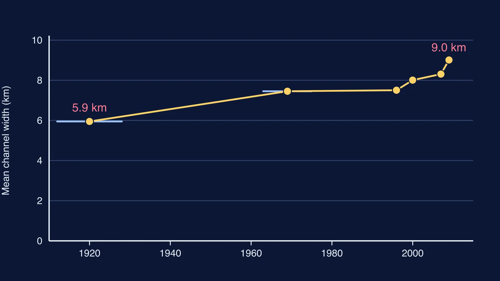
Jogendra Nath Sarma and Shukla Acharjee measured the river's mean width in Assam growing from 5,949 m in 1912 to 1928 to 9,012 m in 2009 (Sarma and Acharjee 2018). They link the widening to the enormous sediment load released by the great Assam earthquake of 1950 and to large-scale deforestation in the Himalayas, and name sharp swings in flow, heavy sediment, erodible banks and a wide, shallow channel as the main causes of braiding.
Shallow channels with soft banks spread sideways instead of cutting deeper. The IUCN assessment notes the river is sometimes 10 km or more wide in Assam, but narrows to about 1 km where it cuts through rock at Guwahati.
Why do snowmelt and monsoon rain make it worse?
The IUCN assessment says Himalayan rivers have two high-water seasons: one in early summer from snowmelt in the mountains, and one in late summer from monsoon rain. The monsoon spreads over most of Assam by the first week of June, so rain lands on a river already rising.
The same report says summer flow is on average about 12 times winter flow, and up to 20 times in some years. At Pandu, the highest recorded daily discharge was 72,726 cubic metres per second in August 1962, against a low of 1,757 in February 1968. For what monsoon totals mean on the ground, see what 100 mm of rainfall means in litres per square metre.
How do you explain Assam floods in a Class 9 answer?
Use a five-step chain. Each step makes the next one worse.
Source: young Himalayas erode fast and feed the river silt.
Slope: the river drops steeply, then flattens in the Assam valley.
Silt: slow water drops its load and raises the bed.
Split: the river braids into wide, shallow channels with soft banks.
Swell: snowmelt, then monsoon rain, push water over the banks.
Worked example with the numbers above. Width change, from Sarma and Acharjee: (9,012 minus 5,949) divided by 5,949 is 3,063 over 5,949, about 0.51, so the channel is roughly 51 percent wider than a century ago. Flow range at Pandu, from the IUCN assessment: 72,726 divided by 1,757 is about 41, so the record flood carried over 40 times the record low flow.
If a parent asks why it happens every year, try this: "The river brings down so much mud that it fills its own bed and splits into shallow channels. Then snowmelt and monsoon rain arrive, and the water has nowhere to go but sideways."
The silt that reaches the sea builds land, which is the story of why the Ganga and Brahmaputra form such a huge delta. For why some monsoons are weaker than others, see how El Niño affects the Indian monsoon.
A slowing river dropping its load is easier to see than to read, and the Fermi Simulation Lab has interactive simulations for ideas that work that way.