
On this page
Monsoon forecasts from the India Meteorological Department (IMD) include a line on El Niño in the Pacific and a line on the Indian Ocean Dipole. The second can push India's rain up or down.
What is the Indian Ocean Dipole?
The Indian Ocean Dipole (IOD) is the difference between sea surface temperatures in the tropical western Indian Ocean, near Africa, and the eastern Indian Ocean, near Indonesia, according to Australia's Bureau of Meteorology. It has three phases: positive, neutral and negative.
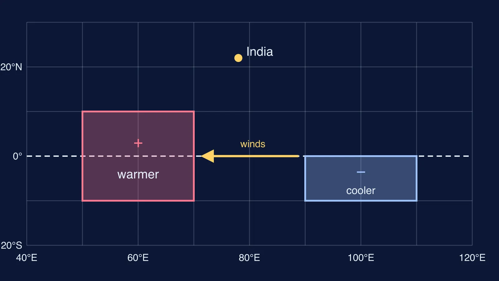
Scientists track it with the Dipole Mode Index: the temperature anomaly in a western box (50°E to 70°E, 10°S to 10°N) minus the anomaly in an eastern box (90°E to 110°E, 10°S to the equator), as set out in a 2018 study in Scientific Reports.
The pattern was reported in 1999 by N. H. Saji, B. N. Goswami, P. N. Vinayachandran and T. Yamagata in Nature. From 40 years of observations, they found it accounts for about 12% of Indian Ocean sea surface temperature variability, is independent of El Niño, and in active years brings severe rain to eastern Africa and drought to Indonesia.
IOD events usually start around May or June and peak between August and October, the Bureau of Meteorology says, overlapping India's monsoon.
What happens to winds and sea temperature in each phase?
In a neutral year, winds along the equator blow from the west, according to the Bureau of Meteorology.
Positive IOD: the westerly winds weaken and sometimes easterlies form. Warm water shifts towards Africa, and cool water rises from the deep ocean south of Indonesia. West warmer, east cooler.
Negative IOD: the westerlies strengthen and warm water gathers in the east. East warmer, west cooler.
Rain tends to follow the warm water: warm sea heats the air above it, and the moist air rises and builds rain clouds. It is the same rising-warm-air idea behind a sea breeze during the day, on the scale of an ocean.
How does the Indian Ocean Dipole affect the monsoon?
Karumuri Ashok, Zhaoyong Guan and Toshio Yamagata studied Indian summer monsoon rainfall from 1958 to 1997 in Geophysical Research Letters. They found that the IOD and El Niño "complementarily affected" it: when El Niño's link with the monsoon was weak, the IOD's was strong, and vice versa.
A positive IOD often works in the monsoon's favour, at least in central India. Swadhin Behera and J. V. Ratnam found that in positive years moisture from the eastern Indian Ocean is carried to central India, strengthening the monsoon trough (Scientific Reports, 2018). Their paper also notes, citing earlier work, that in 1997, when El Niño and a positive IOD came together, IOD-driven rising air over the Bay of Bengal neutralised the sinking air El Niño brings.
The same study found a positive IOD brings above-normal rain to central India but below normal to the north and south of it. For the Pacific half of the story, read how El Niño affects the Indian monsoon.
What happened in the 2026 monsoon?
On 29 May 2026, IMD expected El Niño to develop, the IOD to stay neutral, and rainfall of 90% of the Long Period Average (IMD press release, 29 May 2026).
The season ended at 87% of the Long Period Average, or 759.4 mm, the fourth lowest since 2001, according to IMD's end-of-season summary.
On 8 October, IMD reported strong El Niño conditions and a neutral IOD, with some international centres expecting a shift to positive near the end of the season (IMD press release, 8 October 2026). IMD has not tied the shortfall to a single cause. But the setup matches the case the research describes: El Niño with no positive IOD to counter it.
How do you read the IOD in a monsoon forecast?
Use this check on IMD's April or May forecast.
Find the El Niño line. Is El Niño, La Niña or neutral expected during June to September?
Find the IOD line. Positive, neutral or negative, and when? One that turns positive only at the end of the season has little time to act.
Put the two together using the cases below.
Read the regional forecast, not only the national number. In May 2026 IMD forecast normal rain for Northeast India but below normal for central and south peninsular India (IMD).
The cases for step 3:
El Niño with a positive IOD: the two can partly cancel out, as in 1997 (Behera and Ratnam).
El Niño with a neutral IOD: no Indian Ocean cushion, as in 2026 (IMD).
A weak El Niño link: the IOD's influence tends to show more clearly (Ashok and colleagues).
If the monsoon itself feels fuzzy, start with what makes the monsoon winds blow.
The hard part is picturing winds and water moving together. The Fermi Simulation Lab has interactive simulations for ideas that are easier to see than to read, and the Fermi Concept Library covers the physics underneath, such as convection.
Next time a forecast says "neutral IOD", you will know which side of the ocean to watch.