On this page
A map tells you where things are and how to get to them, and later geography chapters assume you can read one. This guide follows the current NCERT Class 6 book, with two worked scale sums and a checklist.
What is a map, and what are its types?
NCERT's Class 6 book defines a map as a representation, or a drawing, of some area, looked at as if you were viewing the surface from the top (NCERT, Exploring Society: India and Beyond, Chapter 1). An atlas is a book or collection of maps.
The same chapter names three kinds of map:
Physical maps mainly show natural features such as mountains, oceans and rivers.
Political maps show countries or states, boundaries and cities, such as a map of India with its States, Union Territories and capitals.
Thematic maps show one specific kind of information.
A quick way to tell them apart: mostly mountains, rivers and seas means physical; mostly boundary lines and capitals means political; a key about one topic only means thematic.
What are the three components of a map?
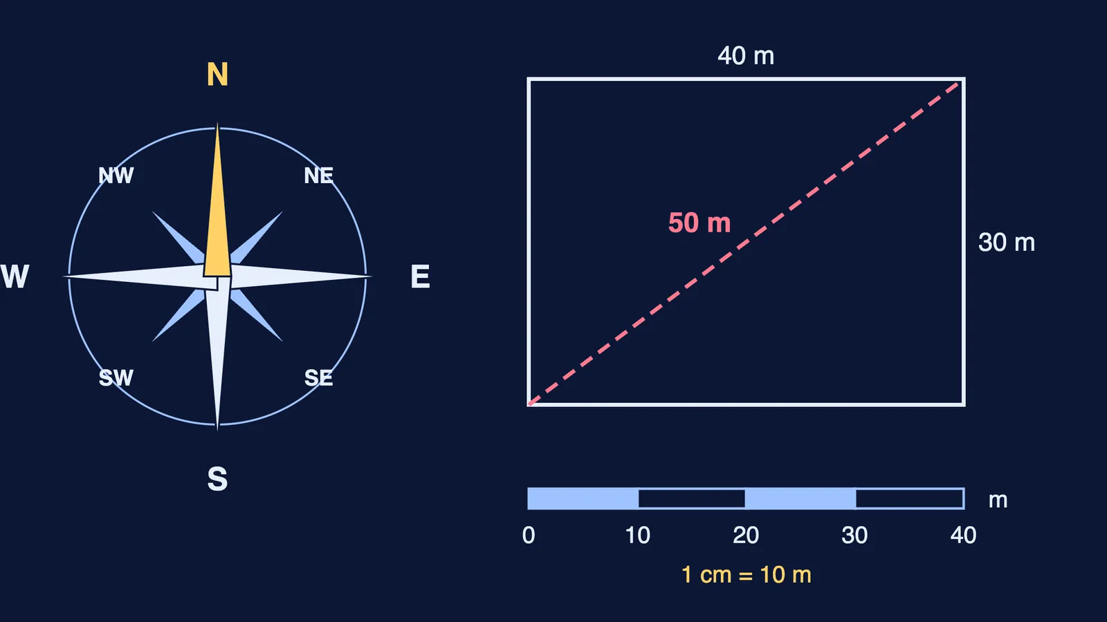
NCERT lists three important components of maps: distance, direction and symbols (NCERT). You read distance from the scale and direction from the north arrow, and on most printed maps a key, or legend, explains the symbols.
How does map scale work?
If each centimetre on a map stands for 500 metres on the ground, the scale is 1 cm = 500 m, the example NCERT uses (NCERT). The real distance between two points always depends on the scale the map uses.
NCERT's Class 11 practical geography book names three ways to show scale: a statement of scale, a representative fraction (R.F.) and a graphical or bar scale (NCERT Practical Work in Geography, Chapter 2). An R.F. of 1 : 24,000 means one unit on the map stands for 24,000 of the same units on the ground. A bar scale stays correct when the map is enlarged or reduced; a written statement does not.
Worked example 1: the playground
The Class 6 chapter asks you to draw a playground 40 m long and 30 m wide at 1 cm = 10 m, then find its diagonal (NCERT).
Divide each ground length by 10: the rectangle is 4 cm by 3 cm.
Measure the diagonal with your ruler: it comes to 5 cm.
Multiply back by 10: the real diagonal is 50 m.
Check it with the 3-4-5 right triangle: 4² + 3² = 25, and the square root of 25 is 5.
Worked example 2: turning a bar scale into an R.F.
On the book's map of India, a ruler 2.5 cm long stands for 500 km on the ground (NCERT).
2.5 cm = 500 km, so 1 cm = 200 km.
200 km = 200,000 m = 20,000,000 cm.
The R.F. is 1 : 20,000,000.
The trap is units: convert both sides to centimetres before you write the ratio. If ratios still feel shaky, the Fermi Problem Library has worked problems with a step-by-step solver that explains the reasoning rather than printing an answer.
How do you find directions on a map?
The four cardinal directions are north, at the top, and then, moving clockwise, east, south and west (NCERT). Between them sit the intermediate directions: northeast (NE), southeast (SE), southwest (SW) and northwest (NW). Most maps show only an arrow marked N.
When a question asks "In which direction is X from Y?", put your finger on Y first, then look towards X. Starting at X gives the opposite answer. Helping a younger sibling? Our guide to teaching directions and simple maps has activities for Classes 3 to 5.
What are conventional symbols on a map?
A map of a large city or a country has no room to draw every building, so map makers use symbols for railway stations, schools, post offices, roads, railway lines, rivers, ponds and forests (NCERT). Different countries use different sets. In India, the Survey of India, a government body, has fixed a set of symbols for maps of India, the chapter says.
A few to learn from the book's chart: PO for a post office, PTO for a post and telegraph office, PS for a police station, RS beside a railway station, a solid double line for a metalled road and a dashed double line for an unmetalled one.
Next, try how to read contour lines on a topographic map and why Greenland looks so big on world maps.
Try this tonight: draw your room at 1 cm = 50 cm, add a north arrow and three symbols, and give it a key.