On this page
Lifelines of National Economy is Chapter 7 of NCERT's Class 10 geography textbook, Contemporary India II. If you are in a CBSE school in 2026-27, know one thing before you open it: the board exam tests this chapter only through the map. Here is what to learn, and a twenty-minute weekly drill for the map.
What does "lifelines of the national economy" mean?
Goods and services do not move from where they are produced to where they are needed on their own, explains the NCERT chapter (2026-27 reprint). Transport moves them, communication carries information, and trade connects buyers and sellers. The chapter says a country's pace of development depends on producing goods and services and on moving them, so efficient transport is a prerequisite for fast development. Hence it calls modern transport and communication the nation's lifelines.
It sorts transport by three domains: land (roadways, railways, pipelines), water (inland and overseas) and air (domestic and international).
What are the main lifelines in the chapter?
Every figure below is from the NCERT chapter, with its year.
Roadways: India has the second largest road network in the world, about 62.16 lakh km (2020-21). Roads cost less to build than railway lines, climb steeper slopes and give door-to-door service.
Railways: the principal mode for freight and passengers. The network runs over 67,956 route km (Railway Yearbook 2019-20) in 17 zones. The first train ran from Mumbai to Thane in 1853, covering 34 km.
Pipelines: high initial cost, minimal running cost, and no trans-shipment losses or delays. India's gas pipelines have grown from 1,700 km to 18,500 km.
Waterways: the cheapest means of transport, suited to heavy and bulky goods. India has 14,500 km of navigable inland waterways, and the National Waterways Act, 2016 declared 111 National Waterways. NW-1 is the Ganga between Prayagraj and Haldia (1,620 km).
Airways: the fastest mode, and the one that reaches high mountains, deserts, dense forests and the north-east.
Communication: the postal network, telecom, and mass media such as radio, television, newspapers and films.
The chapter closes with international trade and tourism as a trade. It gives India's coastline as 11,098.81 km, with 12 major ports and 200 notified non-major ports, and says 95 per cent of India's trade by volume (68 per cent by value) moves by sea. Here is why water transport is cheaper.
What is asked from this chapter in the 2026-27 board exam?
CBSE's Class 10 Social Science curriculum for 2026-27 lists Lifelines of National Economy with the note "Only map pointing to be evaluated in the Board Examination". Geography carries 20 marks, of which 3 are map pointing. The same document makes the chapter part of an interdisciplinary project with History Chapter 3 (The Making of a Global World) and Economics Chapter 4 (Globalisation and the Indian Economy), assessed internally for 5 marks.
The map list for this chapter has two parts:
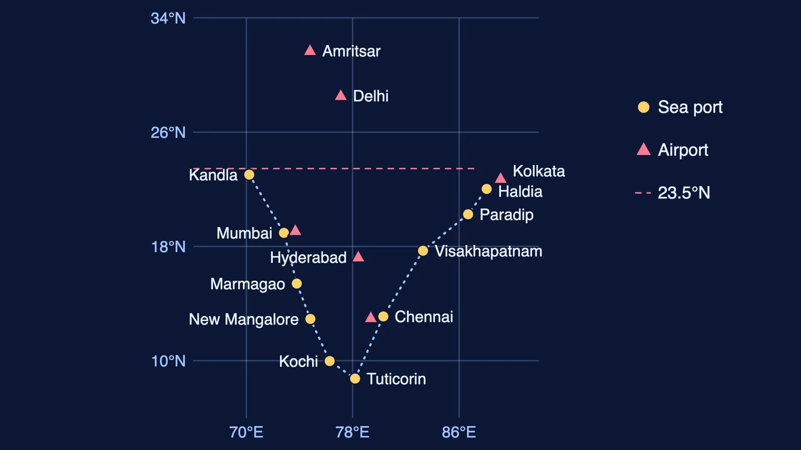
Major sea ports (10): Kandla, Mumbai, Marmagao, New Mangalore, Kochi, Tuticorin, Chennai, Visakhapatnam, Paradip, Haldia.
International airports (6): Amritsar (Raja Sansi, Sri Guru Ram Das Ji), Delhi (Indira Gandhi), Mumbai (Chhatrapati Shivaji), Chennai (Meenambakkam), Kolkata (Netaji Subhash Chandra Bose), Hyderabad (Rajiv Gandhi).
The curriculum adds that items for locating and labelling may also be set for identification. For the list across all chapters, see our Class 10 geography map work plan. The syllabus can change each year, so check the CBSE page before your exam.
How do you remember the ports and airports on the map?
Learn the ten ports as one walk around the coast.
West coast, north to south: Kandla (Gulf of Kachchh), Mumbai, Marmagao (Goa), New Mangalore (Karnataka), Kochi (Kerala).
Round the tip: Tuticorin (Tamil Nadu).
East coast, south to north: Chennai, Visakhapatnam (Andhra Pradesh), Paradip (Odisha), Haldia (West Bengal).
Airports in three pairs: the north (Amritsar, Delhi), two port cities (Mumbai, Chennai), then Kolkata and Hyderabad.
Then run this 20-minute drill once a week:
Five minutes: on a blank outline map, mark all 16 from memory.
Five minutes: check against the map on page 79 of the NCERT chapter and circle every miss.
Five minutes: for each circled item, say one line aloud from the textbook. Mormugao handles about half of India's iron ore export; Paradip specialises in iron ore export; Visakhapatnam is the deepest landlocked port.
Five minutes: identification. Ask someone to mark an unnamed dot and say what it is.
Why learn the rest of the chapter if only the map is tested?
Your school's own tests may still set written questions from the textbook; the NCERT exercises ask, for example, for three merits of roadways and the significance of border roads.
For written answers, our guide to case-based questions in CBSE board exams shows how to pull points from a passage. If your science and maths papers also need a plan, Fermi's AI tutor can work out what you already know and build a plan for the session, so you sit down to a clear next step.