On this page
When civil engineer Kanwar Sain looked across the Thar Desert in the 1940s, he saw dry dunes where summer temperatures frequently crossed 50 °C and rainfall averaged barely 150 to 300 millimetres a year (Indira Gandhi Canal overview). Hundreds of kilometres to the north, snowmelt from the Himalayas surged through the Punjab rivers and escaped unused into the sea. Sain asked a straightforward question that redefined northern India's hydrology: could gravity carry the surplus waters of the Punjab rivers into the heart of the desert?
His answer became the Rajasthan Canal, later renamed the Indira Gandhi Canal, one of the most ambitious irrigation projects ever undertaken. Transforming barren sand into fertile farmland required more than political will; it demanded mastery of open-channel hydraulics, soil mechanics, and large-scale canal lining.
Who was Kanwar Sain?
Born in 1899 in Tohana, Haryana, Kanwar Sain studied at D.A.V. College in Lahore before graduating with honours in civil engineering from Thomason College of Civil Engineering at Roorkee (now IIT Roorkee) in 1927 (Kanwar Sain biography). As Chief Engineer of Bikaner State, he oversaw early operations of the Gang Canal, built by Maharaja Ganga Singh in the 1920s to bring water from the Sutlej.
In October 1948, Sain submitted a landmark report to the Government of India titled *Water Requirements of the Bikaner State* (Lagendijk, 2019). The proposal demonstrated that diverting water from the Sutlej, Beas, and Ravi rivers could reclaim roughly 2 million hectares of arid land across Bikaner and Jaisalmer.
Sain went on to serve as Chairman of the Central Water and Power Commission between 1953 and 1958 (Central Water Commission). He helped plan the Damodar Valley Corporation, the Hirakud Dam, and the Bhakra Dam, before spending nine years as an international river basin expert for the United Nations on the Mekong River project. The Government of India honoured his contributions with the Padma Bhushan in 1956.
Why was the Rajasthan Canal planned from Harike?
Sain recognised that existing irrigation networks could not simply be extended into the desert. The supply needed a dedicated diversion structure capable of managing huge seasonal flood discharges. He selected the confluence of the Sutlej and Beas rivers at Harike in Punjab (Indira Gandhi Canal overview). Construction formally began on 31 March 1958, with the canal later renamed in honour of Indira Gandhi on 2 November 1984.
To convey water across Punjab and Haryana without releasing it along the way, Sain designed the 204-kilometre Rajasthan Feeder (Prasad and Shivay, 2022). Roughly 167 kilometres run through Punjab and Haryana, with the final 37 kilometres crossing into Rajasthan to reach Masitawali Head. From Masitawali, the Indira Gandhi Main Canal extends 445 kilometres south-west through Hanumangarh, Sri Ganganagar, Bikaner, and Jaisalmer to its terminal near Mohangarh, making the primary waterway 649 kilometres long.
Unlike coastal river diversions such as Arthur Cotton and the Godavari anicut or M. Visvesvaraya's automatic sluice gates, which managed delta topography or hard rock riverbeds, Sain had to carry water across unstable shifting sand dunes.
How does gravity move water across an almost flat desert?
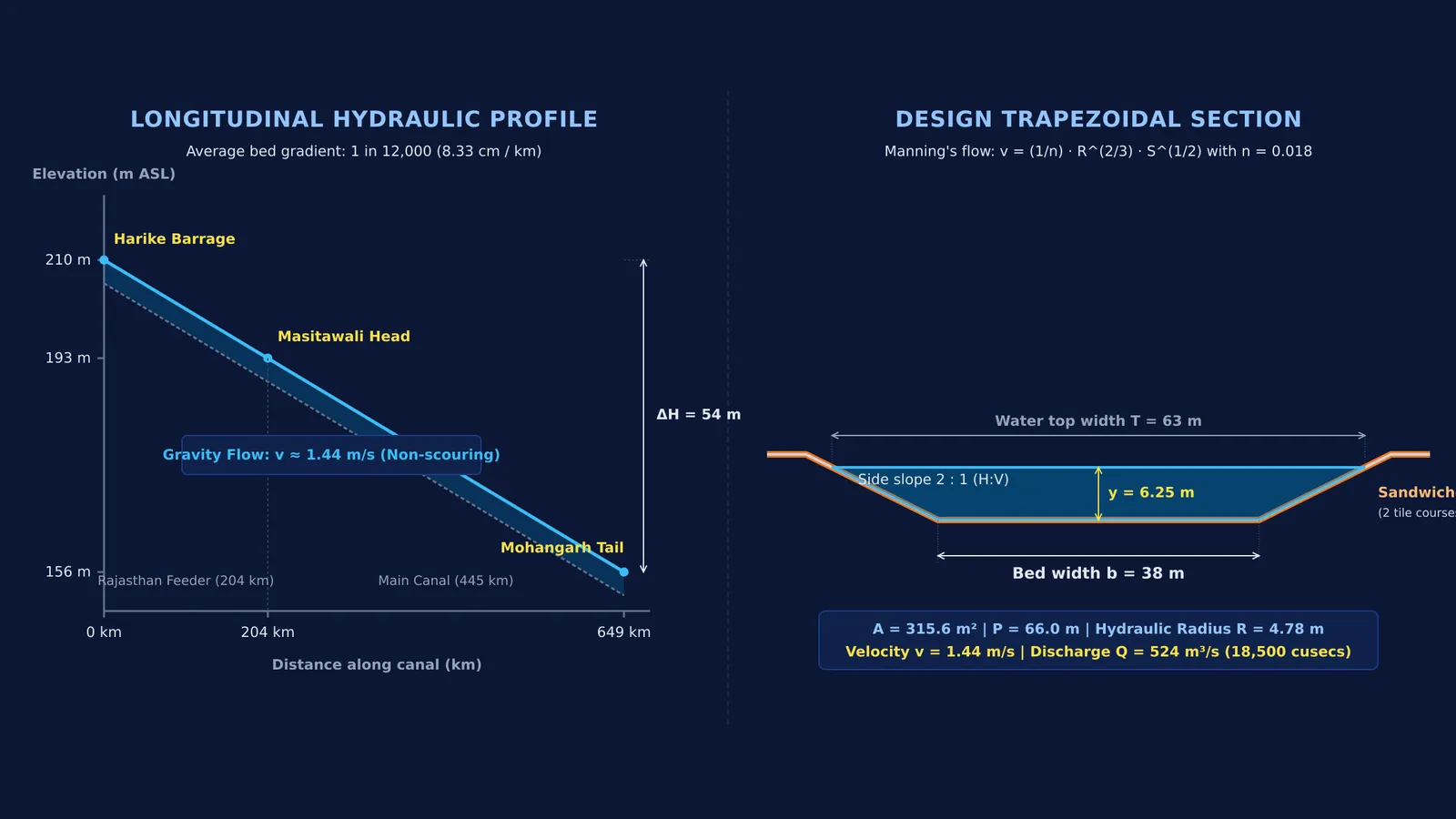
In open-channel hydraulics, water moves under gravity alone. The challenge for Sain was the extremely gentle slope of the land. Between the Harike Barrage at an elevation of roughly 210 metres above sea level and the canal tail near Mohangarh at 156 metres, the total drop is only 54 metres across 649 kilometres (Swamee, Mishra, and Chahar, 20020733-9437(2002)128:4(234))).
This creates an average bed slope of 1 in 12,000, which is a vertical fall of only 8.33 centimetres per kilometre. To deliver a designed discharge of 18,500 cubic feet per second (524 cubic metres per second), Sain's engineering team balanced channel geometry using Manning's equation for open-channel flow (Swamee et al., 20020733-9437(2002)128:4(234))):
v = (1/n) × R^(2/3) × S^(1/2)
Here, v is flow velocity, n is the boundary roughness coefficient, R = A/P is the hydraulic radius, and S is the bed slope (1/12000 ≈ 0.0000833).
For the trapezoidal lined section with bed width b = 38 metres, water depth y = 6.25 metres, and 2:1 side slopes (horizontal to vertical):
Cross-sectional area: A = (b + 2y) × y = (38 + 12.5) × 6.25 = 315.6 square metres.
Wetted perimeter: P = b + 2y√(1 + 2²) = 38 + 12.5√5 ≈ 66.0 metres.
Hydraulic radius: R = A / P = 315.6 / 66.0 ≈ 4.78 metres.
Using a design roughness of n = 0.018 for smooth brick tile lining per Indian Standard 10430 (Swamee et al., 20020733-9437(2002)128:4(234))), the velocity evaluates to:
v = (1 / 0.018) × (4.78)^(2/3) × (1 / 12000)^(1/2) ≈ 1.44 metres per second.
Discharge equals area multiplied by velocity (Q = A × v), yielding roughly 455 to 524 cubic metres per second under full operational head. A velocity around 1.4 metres per second sits within the self-cleaning non-scouring range: fast enough to prevent silt from settling and clogging the bed, but gentle enough to preserve the tile lining.
When studying fluid dynamics, students often mix up static pressure head with gravity-driven energy gradients; our guide on common Bernoulli and fluid mistakes details how open systems behave differently from closed pipes.
When fluid mechanics problems feel abstract on paper, the Fermi Simulation Lab provides interactive simulations for the ideas that are easier to see than to read, letting you observe how velocity profiles respond to changes in bed slope and channel shape.
What made the Indira Gandhi Canal an engineering marvel?
Building a massive canal through loose desert terrain presented severe physical obstacles:
Seepage prevention: An unlined canal dug into sand would lose 30% to 50% of its water to seepage before reaching Rajasthan (Swamee et al., 20020733-9437(2002)128:4(234))). Sain specified a sandwiched brick tile lining: two layers of burnt clay tiles enclosing an impermeable layer of 1:3 cement mortar.
Dune stabilization: Shifting dunes 10 to 30 metres tall threatened to fill the excavated bed. Teams planted extensive shelterbelts of *Acacia tortilis* and *Dalbergia sissoo* along both banks to bind the sand (Prasad and Shivay, 2022).
Lift canal engineering: Because the land on the canal's eastern bank slopes upward, gravity flow could not reach settlements in Churu, Bikaner, or Jodhpur. Engineers installed seven major lift systems (Central Water Commission). The first and longest, lifting water nearly 60 metres, was named the Kanwar Sain Lift Canal in his honour.
Today, the canal network spans over 9,000 kilometres of distributaries, irrigating nearly 1.96 million hectares and providing drinking water to millions (Prasad and Shivay, 2022).
If you encounter challenging fluid dynamics numericals on open-channel flow, the Fermi Problem Library offers worked problems with a step-by-step solver that explains the reasoning rather than printing an answer.