
On this page
Why did measuring one degree of latitude matter in 1670?
In the seventeenth century, European navigators and astronomers lacked a reliable measure of Earth's dimensions, as noted by the MacTutor History of Mathematics archive. Discrepancies between older estimates left sea charts distorted and prevented astronomers from establishing dependable planetary scales. In 1668, Jean-Baptiste Colbert tasked the Académie des Sciences with mapping France with mathematical rigor.
The central challenge was measuring the length of one degree of latitude along a meridian. Knowing the linear ground distance for an angular shift of one degree allows you to multiply by 360 to find Earth's circumference. Earlier attempts by Willebrord Snellius and Giovanni Battista Riccioli suffered from short baselines and imprecise open sights. French astronomer and priest Jean Picard realized that geodesy required a new standard of optical precision.
How did Jean Picard measure the meridian arc?
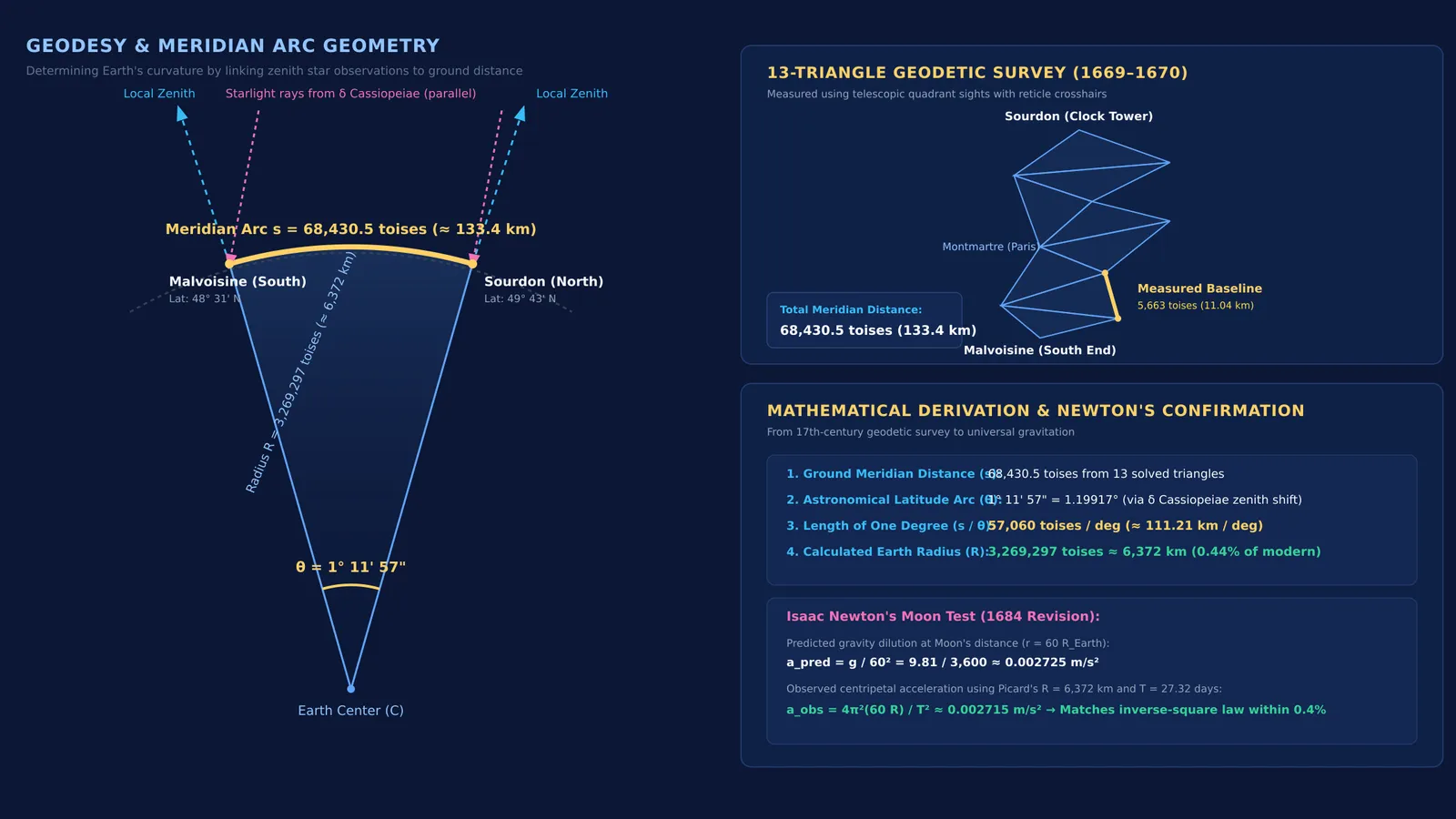
Between 1669 and 1670, Picard surveyed a meridian arc from Malvoisine, south of Paris, to the clock tower of Sourdon, near Amiens. Rather than measuring the entire distance directly on the ground, he turned to triangulation.
His key breakthrough was attaching telescopes with crosshairs to his quadrants. According to the American Physical Society, this innovation reduced angular sighting uncertainty from four minutes of arc down to ten seconds.
As recorded in the Philosophical Transactions of the Royal Society, Picard's survey proceeded in four methodical steps:
Baseline measurement: Along the paved highway between Villejuif and Juvisy, Picard measured a straight baseline of 5,663 toises (about 11.04 km) using four wooden rods.
Triangulation network: From this baseline, he sighted church towers and beacons to construct a chain of 13 triangles connecting Malvoisine to Sourdon.
Terrestrial distance: Solving the triangles, Picard determined the meridian distance between the parallels of Malvoisine and Sourdon to be 68,430.5 toises.
Celestial arc: Using a 10-foot zenith sector to track the star δ Cassiopeiae, Picard found an angular latitude difference of 1° 11' 57" (1.19917°).
Dividing 68,430.5 toises by 1.19917° gave 57,060 toises per degree of latitude, published in his 1671 book *Mesure de la Terre*. At 1.949 metres per Paris toise, one degree equalled 111.21 km. This yielded an Earth radius of 3,269,297 toises, or roughly 6,372 km—within 0.44% of modern measurements.
How did Isaac Newton use Picard's Earth radius?
Picard's measurement provided the critical figure for Isaac Newton's law of universal gravitation, as recounted by the American Physical Society. In 1666, young Newton hypothesized that the force pulling an apple to Earth also holds the Moon in orbit, decaying with the inverse square of distance (1/r²).
Because the Moon is roughly 60 Earth radii away, Earth's gravity at the Moon must be 60² = 3,600 times weaker than at the surface. With surface gravity g ≈ 9.81 m/s², the Moon's predicted inward acceleration is:
a = 9.81 / 3,600 ≈ 0.002725 m/s²
To check this against observation, Newton calculated the Moon's centripetal acceleration from its orbital period (T ≈ 27.32 days = 2,360,592 seconds) and radius (R_moon = 60 × R_Earth):
a = 4π²(60 × R_Earth) / T²
In 1666, Newton relied on an old sailing estimate of 60 miles per degree, giving an Earth radius of roughly 5,500 km. That 15% error yielded an acceleration of only 0.0023 m/s², leading him to set the calculation aside.
Around 1684, Newton adopted Picard's radius of 6,372 km to re-evaluate the lunar orbit:
a = 4 × (3.14159)² × (60 × 6,372,000) / (2,360,592)² ≈ 0.002715 m/s²
The observed acceleration matched the predicted 1/3,600 dilution within 0.4%. You can explore these mechanics in an interactive orbits and gravity simulation. To see how mass and distance govern gravitational fields across space, the Fermi Simulation Lab provides interactive simulations for ideas that are easier to see than to read.
What can students learn from Picard's triangulation?
Picard's survey offers practical guidance for physics students tackling gravitation and measurement problems:
Connect celestial orbits to terrestrial dimensions: Finding an orbital velocity or acceleration requires Earth's physical radius in metres, not just angular coordinates. Learn more about deriving global metrics in our guide on finding the density of Earth from g and its radius.
Maintain unit discipline: Convert all angular measures into radians before using the arc length relation s = Rθ.
Validate data before doubting principles: Newton needed accurate geodetic data before his universal law could be confirmed.
Focusing on underlying mechanisms is essential when learning physics from first principles. When solving multi-step gravitation problems, the Fermi Problem Library provides worked problems with a step-by-step solver that explains the reasoning rather than printing an answer.