
On this page
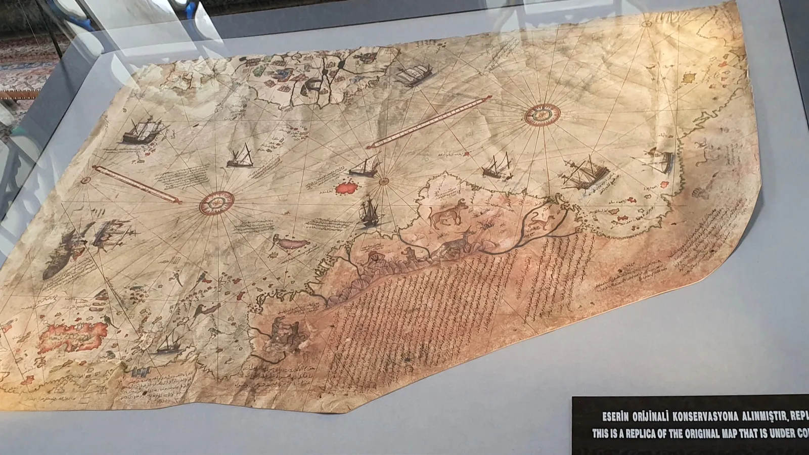
In 1929, scholars in Istanbul's Topkapı Palace rediscovered a fragment of a world map made by an Ottoman sea captain. Almost a century later, that fragment still gets passed around online as proof of lost civilisations. The real story is better: it shows a working navigator collecting every chart he could find and combining them into one picture of a world that was changing fast.
Who was Piri Reis?
Piri Reis, born Muhiddin Piri, was an Ottoman admiral and cartographer, born around 1465 to 1470 in Gallipoli (Gelibolu), according to his Wikipedia biography. He learned the sea under his uncle Kemal Reis, a corsair in the Mediterranean. Besides the map, he wrote the Kitab-ı Bahriye (Book of the Sea), a guide for sailors whose first version was composed between 1511 and 1521, with an expanded version presented to the sultan in 1526. After a failed campaign against the Portuguese at Hormuz, he was beheaded in Cairo in 1553.
What does the Piri Reis map of 1513 actually show?
The map is dated 919 in the Islamic calendar, which is 1513, and is drawn on gazelle-skin parchment about 87 cm by 63 cm, according to the Wikipedia article on the map. Only about a third of the original world map survives.
The surviving piece shows the Atlantic Ocean with the western coasts of Europe and North Africa, the coast of Brazil, and Atlantic islands such as the Azores and the Canary Islands, as described by the Foundation for Science, Technology and Civilisation. It is a portolan chart: sailors steered by compass roses and a web of straight lines of bearing, not by a grid of latitude and longitude.
Piri presented the map to Sultan Selim I after the Ottoman conquest of Egypt in 1517, according to the same Wikipedia article.
Which earlier maps did Piri Reis copy from?
Piri wrote his method on the map itself. His notes say he used about 20 charts and world maps (mappae mundi), including these, as listed in the Wikipedia article on the map:
eight maps in the Ptolemaic tradition, going back to ancient Greek geography
one Arabic map of India
four newly drawn Portuguese maps of Asia
a map by Christopher Columbus of the West Indies
A 1980 article in Saudi Aramco World retells how the Columbus material may have reached him: Kemal Reis reportedly captured Spanish ships around 1501, and one sailor aboard had sailed with Columbus and carried a map Columbus had drawn. The historian Gregory McIntosh, in The Piri Reis Map of 1513 (2000) argues that the map draws on Columbus's Second Voyage rather than his Third.
Does the Piri Reis map show Antarctica?
No. The claim comes mainly from Arlington Mallery and the historian Charles Hapgood, whose 1966 book Maps of the Ancient Sea Kings argued that the southern coast on the map was an ice-free Antarctica, as summarised on Wikipedia. Hapgood argued that the chart used an equidistant projection centred on Cairo (Saudi Aramco World).
The geologist Paul Heinrich pointed out two problems in his analysis of the claim. First, Hapgood assumed that every mismatch was a copying error made when the source maps were combined, so the source maps he reconstructed were bound to look accurate. Second, the dates do not work: Heinrich writes that Antarctica was covered by a fully developed ice cap between 40,000 and 6,000 years ago, and was last completely ice-free over 14 million years ago.
A plainer explanation, set out in the same Saudi Aramco World article, is that Piri was running out of parchment near the Río de la Plata and turned the coastline eastward; viewed upright, that southern section closely resembles the real east coast of South America. McIntosh's book likewise rejects readings of the map as evidence of ancient civilisations or visitors from space.
How can you check a mystery map claim yourself?
Here is a five-step check, worked on the Antarctica claim:
Read the maker's own words. Piri lists his sources on the map: older charts, not a lost civilisation.
Look at the original, not a redrawing. Many images of Piri's Antarctica are modern reconstructions.
Ask what had to change for the claim to fit. Hapgood assumed a special projection and treated every mismatch as a copying error.
Test it against another subject. Geology says Antarctica was last fully ice-free over 14 million years ago.
Prefer the simpler story that fits all the evidence. A coastline bent to fit the edge of a gazelle skin needs nothing new.
Every flat map of a round Earth bends something, and the projection decides what. If projections, angles on a sphere or scale feel shaky, the Fermi Concept Library has every concept in mathematics, each with its own lesson. And if you are not sure where to start, Fermi's AI tutor can work out what you already know and build a plan for the session.
Next time someone sends you the Piri Reis map as a mystery, send back its list of about 20 sources. It is the more interesting story.