
On this page
Maria Reiche arrived in Peru as a governess and ended up as the main mapmaker and guardian of the Nazca lines, giant drawings scraped into the desert south of Lima. She measured them by hand, argued that they were a calendar written on the ground, and spent her own money on guards. Later tests cast doubt on her astronomy idea, but her measurements and protection work lasted.
Who was Maria Reiche?
Reiche was born in Dresden on 15 May 1903, moved to Peru in 1932 to work as a governess and tutor, and died in Lima on 8 June 1998, aged 95, according to her Wikipedia biography. The same page says she studied mathematics and astronomy in Dresden and first saw the Nazca lines from the air in 1941, while assisting the American historian Paul Kosok.
The Women in World History entry on Reiche says she graduated in Dresden in 1928. At sunset on 22 June 1941, the winter solstice in Peru, Kosok saw a long straight line pointing at the setting sun. Six months later Reiche saw another line pointing towards the summer solstice.
How did Maria Reiche map the Nazca lines?
UNESCO's description, reproduced by the Bradshaw Foundation, says the lines cover about 450 km² and were made between 500 BC and AD 500. National Geographic counts over 800 straight lines, 300 geometric figures and 70 animal and plant designs.
Using a measuring tape, a sextant and a compass, Reiche measured almost 1,000 lines, says Google's Doodle page for her 115th birthday. The same page says the figures show 18 different kinds of animals and birds, and that with only a household broom she shielded them from people and vehicles. She also persuaded the Peruvian Air Force to help with aerial photographic surveys, according to her biography.
Did the Nazca lines really point at the stars?
Reiche thought so. She argued that the builders used the lines as a sun calendar and an observatory, and that the giant monkey figure represented the constellation Ursa Major, as her biography summarises.
The astronomer Gerald Hawkins tested the idea by computer on 186 lines: 39 matched major Sun and Moon directions, but about half of those matches could be explained by pure chance, according to the EBSCO research summary on the Nasca lines. The archaeoastronomer Anthony Aveni later argued in Archaeology magazine that the lines were pathways made to walk on, linked to rituals for getting water.
In a 2024 PNAS study, Masato Sakai and colleagues used an AI system to help find 303 new figurative geoglyphs within six months of field survey, nearly doubling the number known.
How can you test a line for a solstice alignment yourself?
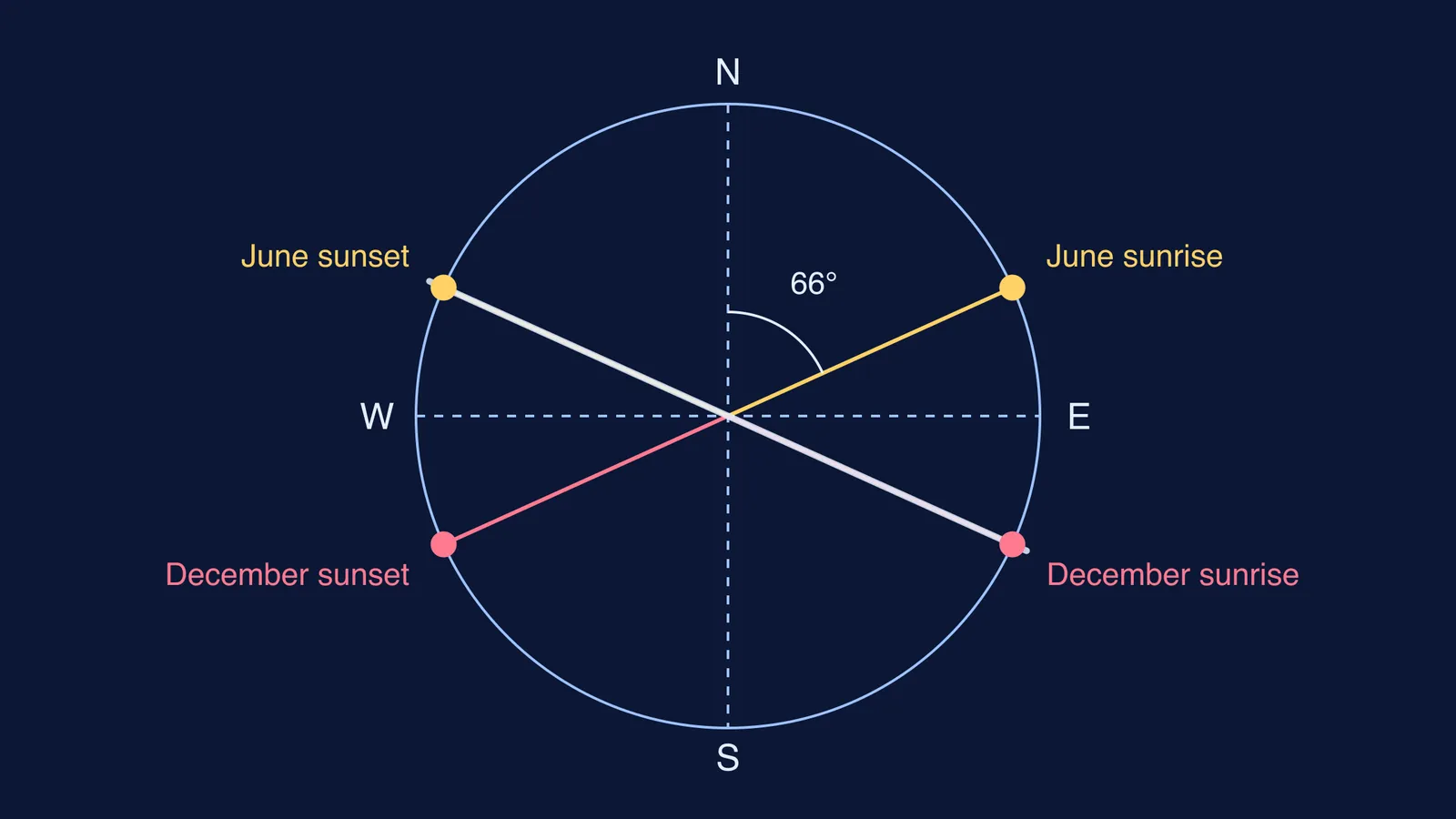
For a flat horizon, the Sun rises at a solstice at an angle A east of north, where cos A = sin δ ÷ cos φ. Here δ is the Sun's declination at the solstice, about 23.44° today, and φ is your latitude.
Find the latitude. The lines lie at about 14.70° S, from the coordinates of the Nazca lines.
Work it out: sin 23.44° = 0.398 and cos 14.70° = 0.967, so cos A = 0.411 and A ≈ 65.7°.
List the four solstice directions: June sunrise at 65.7°, December sunrise at 114.3°, December sunset at 245.7° and June sunset at 294.3°.
Notice that a straight line has two ends. A line running from 114.3° to 294.3° points at December sunrise one way and June sunset the other. So one line gives two hits.
Ask how often chance gives the same result. Count a hit if a line lies within 1° of either solstice axis. That makes a window of 4° out of the 180° a line's direction can take, about 2.2%. Out of 1,000 lines pointing in random directions, you would expect about 22 hits even if nobody planned them.
How did she protect the lines?
Reiche published The Mystery on the Desert in 1949. She used the profits from the book to campaign for the desert's protection and to hire guards, and she sponsored a tower near the highway so visitors could view the lines without damaging them, according to her biography. Peru gave her the Order of the Sun in 1993, and she became a Peruvian citizen in 1994, according to Women in World History.
UNESCO listed the lines as World Heritage in 1994, says the Nazca lines entry. Threats continued: in 2018 a truck left tyre marks across three geoglyphs, over about 46 m by 107 m.
What can students take from Maria Reiche?
Reiche's tools were simple: a tape, a sextant and a compass, used with patience. If the azimuth formula felt shaky, the Fermi Concept Library gives every concept in physics, chemistry, biology, mathematics and computing its own lesson. Sunrise points that shift with the seasons are easier to see than to read, and the Fermi Simulation Lab offers interactive simulations for ideas like that.
Now try step 5 with a 2° window and see how fast chance matches grow.