On this page
What was the Tabula Rogeriana?
In the mid-twelfth century, Palermo was a vibrant Mediterranean intellectual crossroads where Norman, Arab, Byzantine, and Latin scholars met under King Roger II of Sicily, whose royal court is recognized today as a UNESCO World Heritage site. Roger II was frustrated by contradictions in European and Arab geography manuscripts. Around 1138, he commissioned the Andalusian scholar Muhammad al-Idrisi (c. 1100–1166) to direct an ambitious project: creating a verified, comprehensive atlas of the known world.
Completed in January 1154, the project produced three related works, as documented by S. Maqbul Ahmad in The History of Cartography: a silver planisphere disc weighing approximately 134 kg, a world atlas divided into 70 regional sheets, and an Arabic geographical text titled *Nuzhat al-mushtaq fi ikhtiraq al-afaq* ("The Excursion of One Who Yearns to Penetrate the Horizons"). Later scholars called this composite work the *Tabula Rogeriana* (The Book of Roger), preserved today in early manuscript copies catalogued by the Library of Congress.
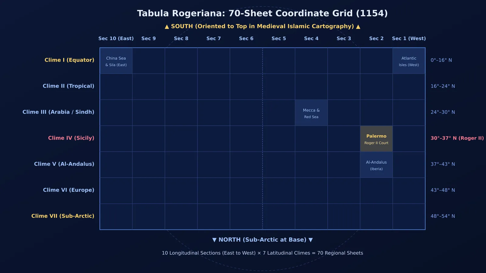
Al-Idrisi treated the Earth as a sphere suspended in space like the yolk inside an egg. Following Ptolemy and earlier Islamic treatises documented in The History of Cartography, he divided the inhabited Northern Hemisphere into seven latitudinal climate zones from the Equator to the sub-Arctic. Al-Idrisi's key innovation was dividing each climate zone longitudinally into 10 sections, producing a 70-sheet coordinate grid that mapped Eurasia and North Africa.
How did al-Idrisi verify travellers' reports?
Unlike medieval *Mappa Mundi* schemas that filled blank spaces with monsters and folklore, Roger II and al-Idrisi insisted on empirical observation. Because Palermo and Messina were bustling maritime ports, the court questioned arriving captains, merchants, and pilgrims.
In his preface, documented by S. Maqbul Ahmad in The History of Cartography, al-Idrisi explained that witnesses were questioned "both singly and collectively" over 15 years. Scribes recorded distances in marching days, sailing leagues, and mountain passes. When accounts conflicted, informants were questioned together to resolve discrepancies.
If travellers disagreed on coordinates or travel times, al-Idrisi discarded the claim. Only landmarks corroborated by multiple independent witnesses reached the drafting table. When interviews left doubts, Roger II sent draftsmen on targeted reconnaissance journeys to observe the terrain directly.
Why was the map drawn with South at the top?
Modern readers often find the *Tabula Rogeriana* disorienting because North appears at the bottom and South at the top. This orientation was standard in medieval Islamic cartography, including the Balkhi tradition examined in The History of Cartography. Placing South at the top oriented the map toward Mecca for North African and Middle Eastern scholars, while highlighting Mediterranean and Indian Ocean sea routes.
The atlas organized geographic coordinates centuries before European navigators adopted the rhumb-line charts described in our study of Gerardus Mercator's map projection. Later, cartography shifted from physical itineraries to satellite geodesy, an evolution explored in our profile of Gladys West's satellite Earth model. Yet for over 300 years following 1154, al-Idrisi's 70-sheet atlas, preserved in manuscript records at the Library of Congress, remained the most accurate representation of the known world.
How can students use al-Idrisi's cross-referencing method?
Al-Idrisi's method provides a practical template for students tackling competitive STEM exams like JEE and NEET. When learning challenging topics—such as rotational dynamics or reaction mechanisms—students often consult textbooks, reference guides, and video lectures that present conflicting notations, shortcuts, or partial derivations.
You can apply al-Idrisi's four-step cross-referencing framework to reconcile conflicting sources:
Record source steps separately: Note formulas and derivations from each reference without assuming any single author is infallible.
Interrogate discrepancies: Compare conflicting explanations side by side to spot hidden assumptions, such as unstated ideal-gas conditions or frictionless surfaces.
Validate through first principles: Test disputed formulas against dimensional consistency and boundary limits. Combining text with diagrams also improves recall, as outlined in our guide on dual coding in science notes.
Build one verified master sheet: Keep a single notebook per chapter that retains only derivations verified across independent checks.
When you encounter conflicting explanations across different reference books or want to see where a theorem fits in the wider subject, the Fermi Concept Library provides structured lessons for every concept in physics, chemistry, biology, mathematics and computing, each with its own lesson and its place in the map. When working through complex multi-step numericals where different study guides skip steps or take divergent algebraic paths, the Fermi Problem Library offers worked problems with a step-by-step solver that explains the reasoning rather than printing an answer.