

On this page
What drives the monsoon winds toward India?
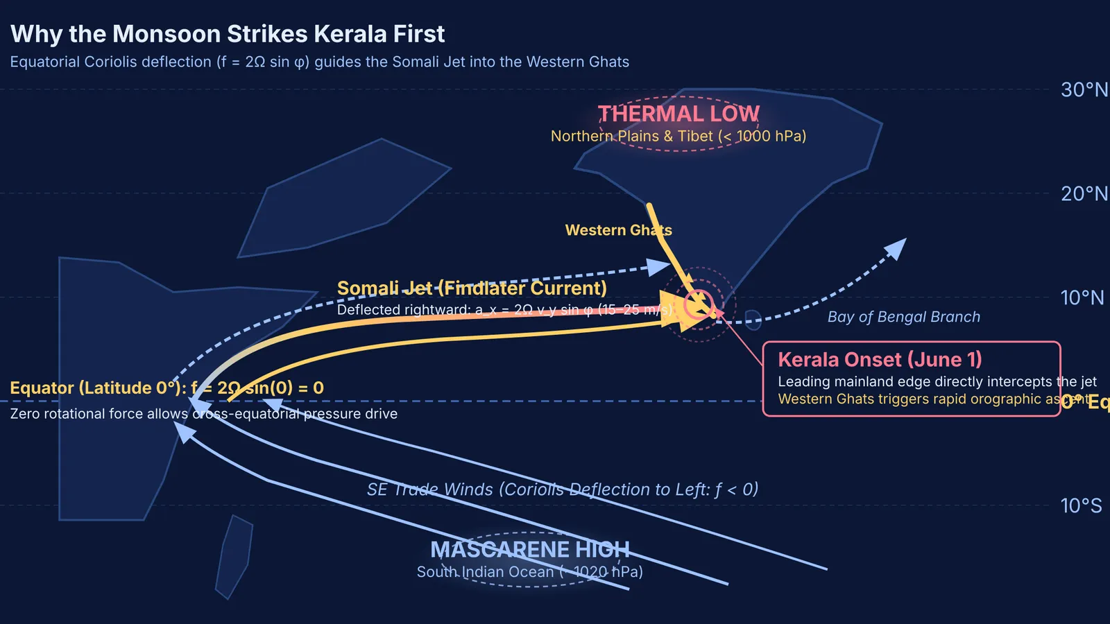
Differential heating between land and ocean drives the South Asian monsoon, as detailed by Webster et al. (1998). Water has a high specific heat capacity of roughly 4,184 J/(kg·K), storing heat across metres of depth. Dry continental soil, with a specific heat capacity near 800 J/(kg·K)—one-fifth that of water—warms far faster. Between March and May, northwestern India heats past 40 °C, carving out a continental low below 1000 hPa. The southern Indian Ocean stays cooler near the Mascarene High at 30°S around 1020 hPa. This 20 hPa pressure gradient pulls maritime air northward, building on patterns first quantified in Henry Blanford's early monsoon forecasting.
Why does the wind turn into a south-westerly flow?
In the Southern Hemisphere, trade winds blow northwestward. Their path is governed by Coriolis acceleration, -2 Ω × v, analyzed by Webster et al. (1998). The Coriolis parameter is f = 2Ω sin φ, with Earth's rotation rate Ω = 7.292 × 10⁻⁵ rad/s and latitude φ. South of the equator (φ < 0°), negative f deflects air to the left. At the equator (φ = 0°), f vanishes, allowing pressure gradients to push maritime air across without rotational deflection. In the Northern Hemisphere (φ > 0°), positive f deflects winds to the right, turning the airstream into a south-westerly flow.
In 1969, meteorologist J. Findlater showed that this flow concentrates along East Africa into the Somali Jet. Channeled between highlands and ocean, winds accelerate across the Arabian Sea at 15 to 25 metres per second (30 to 50 knots) toward peninsular India. This flow couples with the planetary pressure seesaws described in Gilbert Walker's southern oscillation work.
Why does the mainland rain start at Kerala's coast?
Two geographic factors make Kerala the first mainland recipient of the monsoon: peninsular geometry and coastal orography, catalogued by D. S. Pai and M. Rajeevan (2009). Peninsular India tapers southward to Cape Comorin at latitude 8.1°N, with Kerala spanning the southwestern margin between 8°N and 12°N. When the south-westerly Somali Jet sweeps across the Arabian Sea, Kerala lies directly in its path. Although the Andaman and Nicobar Islands intercept rain bands in mid-May, Kerala is the gateway to the mainland.
Behind Kerala stands the Western Ghats, averaging 900 to 1,200 metres with peaks reaching 2,695 metres at Anamudi. As the moist jet strikes this barrier, orographic ascent begins:
Mechanical forcing lifts maritime air up steep windward slopes.
Expanding under lower pressure, air cools adiabatically at roughly 9.8 °C per kilometre to condensation.
Condensation releases latent heat of vaporization (roughly 2.5 × 10⁶ J/kg), maintaining positive buoyancy and fuelling deep cumulonimbus clouds.
Satellite observations, pioneered in India by P. R. Pisharoty's remote sensing investigations, confirm that this abrupt orographic lift produces the deluge known as the monsoon burst.
How does the IMD officially declare the monsoon onset?
The India Meteorological Department (IMD) avoids declaring onset from isolated pre-monsoon thundershowers. According to official climatological records from the Ministry of Earth Sciences, the normal onset date over Kerala is June 1, with a standard deviation of about 7 days. In their landmark study, D. S. Pai and M. Rajeevan (2009) established three mandatory criteria evaluated simultaneously after May 10:
Rainfall: At least 60% of 14 designated stations in Kerala, Lakshadweep, and coastal Karnataka (such as Thiruvananthapuram, Kochi, Kozhikode, Minicoy, and Mangaluru) must report daily rainfall of 2.5 mm or more for two consecutive days, with onset declared on day two.
Westerly wind depth: Westerly winds must reach up to 600 hPa (about 4,500 metres altitude) across the equatorial box (Equator to 10°N, 55°E to 80°E), with 925 hPa zonal speeds of 15 to 20 knots.
Outgoing Longwave Radiation: Satellite OLR over the southeastern Arabian Sea (5°N to 10°N, 70°E to 75°E) must fall below 200 W/m², confirming cold, high cloud tops rather than clear sea.
How do the governing physics equations explain the onset?
Students can trace the onset mechanism through classical equations synthesized in Webster et al. (1998):
Thermal disparity: From Q = m c ΔT, dry soil (c ≈ 800 J/(kg·K)) warms five times faster than water (c ≈ 4,184 J/(kg·K)) under equal solar flux, driving continental heating.
Pressure gradient: The ideal gas law P = ρ R T and hydrostatic balance dP/dz = -ρ g show that warm, less dense air creates a surface low.
Coriolis turning: The acceleration a_x = 2 Ω v_y sin φ steers northward air eastward, reaching a_x ≈ 5.06 × 10⁻⁴ m/s² at 10°N for a 20 m/s wind.
Latent heat release: As humid air climbs the Ghats, condensing water releases L_v ≈ 2.5 × 10⁶ J/kg, driving deep convection.
Visualising fluid dynamics across a rotating frame is easier with interactive models. The Fermi Simulation Lab provides interactive simulations for the ideas that are easier to see than to read, showing how planetary rotation and heating guide regional winds. When calculating mechanics or thermodynamics numericals, the Fermi Problem Library has worked problems with a step-by-step solver that explains the reasoning rather than printing an answer.


