

On this page
When you turn on a tap and clean water flows out, it is easy to forget that this resource is finite. For students studying environmental science or geography, understanding water as a resource is crucial. The reality is that beneath the ground, the hidden reserves that supply millions of homes and farms are steadily shrinking.
What are aquifers and the water table?
To understand the crisis, you must first understand how water is stored underground. When rain falls, some of it runs off into rivers, but a large portion soaks into the soil. It trickles down through permeable layers of rock, sand, and gravel until it hits an impermeable layer of solid rock.
The saturated zone where water is held in the microscopic spaces of the porous rock is called an aquifer. The upper boundary of this saturated zone is known as the water table. In a healthy environment, the water table rises after heavy monsoon rains and falls slightly during dry seasons, maintaining a natural balance year after year.
You can explore these fundamental concepts further in our guide to Nature's treasures in Class 6 Curiosity: air, water, forests, soil.
Why is groundwater level falling in many parts of India?
The water table is dropping because we are extracting water much faster than nature can replace it. India is the world's biggest user of groundwater, extracting 251 billion cubic meters in a single year, according to Wikipedia's summary of national water data.
The primary driver of this massive depletion is agriculture. Approximately 89% of the groundwater extracted in India is used for irrigation, often using traditional, inefficient methods (Wikipedia). Many regions heavily rely on water-intensive crops, such as paddy and sugarcane, which require constant flooding of fields. Between 2007 and 2017, the Central Ground Water Board reported that groundwater levels in India decreased by 61% across monitored wells, a stark indicator of this unsustainable practice.
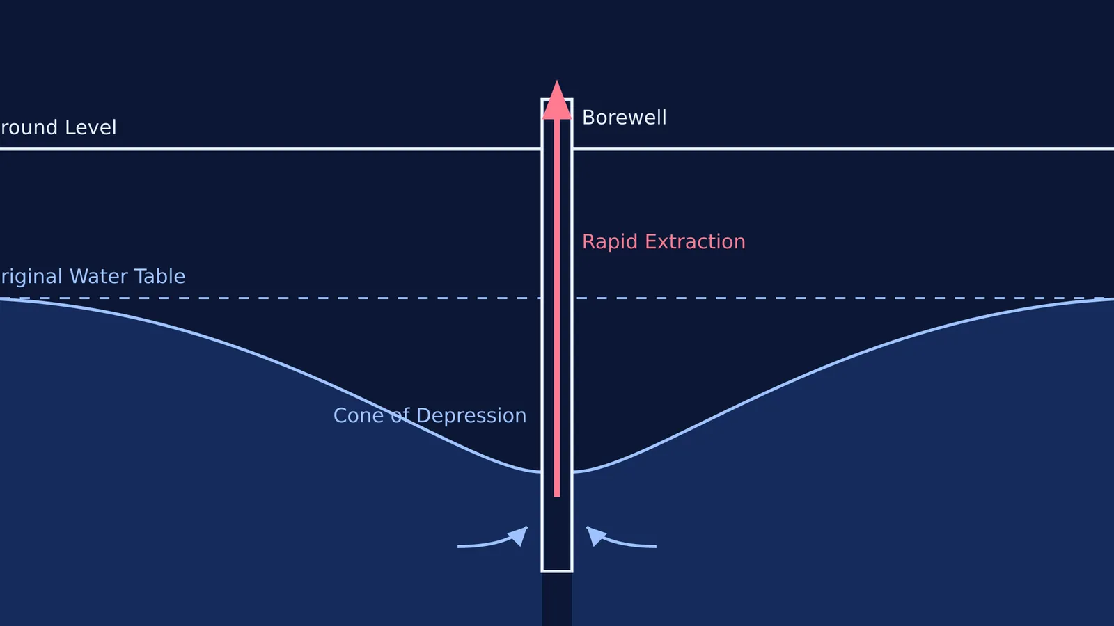
When a borewell—a deep, narrow pipe driven into an aquifer—is activated by an electric pump, it creates a localized drop in the water table called a cone of depression. If thousands of borewells pump continuously across a district, the individual cones merge, and the entire regional water table drops. Because underground fluid flow is hard to picture from a textbook, you can use the Fermi Simulation Lab to run interactive models of aquifers and see exactly how different pumping rates lower a water table.
As the water table drops, the consequences go beyond simply having less water. Communities are forced to drill deeper borewells, which is highly expensive and often yields water of lower quality. Deep aquifers can contain naturally occurring minerals like fluoride and arsenic. When the fresh upper layers are depleted, these harmful elements become more concentrated in the remaining water.
Why is rain not recharging the aquifers?
A falling water table is a simple equation with two sides: extremely high extraction and worryingly low recharge. The recharge side of the equation is failing because India catches only 8% of its annual rainfall (Wikipedia).
Rapid urbanisation has covered vast natural recharge zones with impermeable concrete and asphalt. Instead of soaking into the ground to replenish the aquifer, rainwater becomes surface runoff, overwhelming storm drains and eventually flowing directly into the sea. You can read more about how water moves between these different physical states in our article on A journey through states of water in Class 6: evaporation explained.
Furthermore, climate change has led to more erratic monsoon patterns. When rain falls in short, intense bursts rather than steady showers, the soil cannot absorb it fast enough, leading to higher runoff and even lower groundwater recharge.
A checklist for understanding your local water footprint
If you are studying environmental science for your exams, memorising global statistics is less effective than applying the concepts locally. Use this short checklist to analyze your own region's water resources:
Identify the source: Does your home's water come from a municipal surface reservoir (like a lake or river) or a local borewell?
Track the recharge: Are there rainwater harvesting systems installed in your building or community to catch monsoon runoff?
Observe the surfaces: What percentage of your immediate neighbourhood is covered in concrete compared to open soil, parks, or gardens?
Map the usage: How much water goes toward maintaining lawns or washing cars compared to essential domestic use?
By connecting textbook definitions to the physical world outside your window, you will build a much stronger, practical understanding of why the water table matters and what we can do to protect it.


