

On this page
When the summer sun beats down on the subcontinent, the term "heatwave" dominates the news. But a heatwave is not just a hot day; it is a specific meteorological event defined by strict numbers.
The India Meteorological Department (IMD) uses a two-part test to decide when the heat becomes a hazard. It combines an absolute threshold (a minimum temperature that must be reached) with a relative measure (how much hotter it is than usual).
What temperature counts as a heatwave in India?
For the IMD to consider declaring a heatwave, the actual maximum temperature must first hit a baseline threshold that varies by geography:
Plains: 40 °C or higher
Coastal stations: 37 °C or higher
Hilly regions: 30 °C or higher
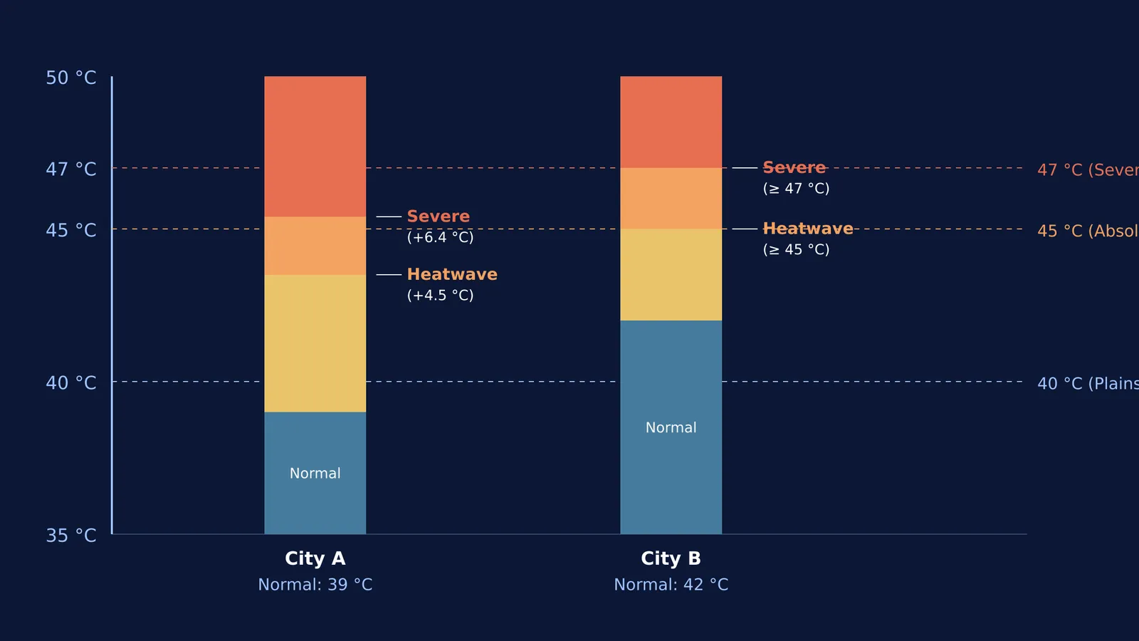
Once that baseline is met, the IMD looks at the departure from normal. A heatwave is declared if the maximum temperature is 4.5 °C to 6.4 °C above the region's normal temperature.
However, if the absolute temperature is extreme enough, the departure rule is bypassed. An actual maximum temperature of 45 °C or more automatically triggers a heatwave warning, regardless of the normal.
How is the "departure from normal" calculated?
To know if a day is abnormally hot, meteorologists must first define "normal". A climate normal is the long-term average of a weather variable, typically calculated over a 30-year period.
If a city in the plains has a normal May temperature of 39 °C, a day that hits 42 °C is 3 °C above normal. While uncomfortable, it does not meet the 4.5 °C departure required for a heatwave. But if another city has a normal of 36 °C and records a temperature of 41 °C, the 5 °C departure triggers a heatwave, even though the absolute temperature is lower than the first city's.
Understanding the difference between absolute values and relative anomalies is a core concept in data analysis. If you find these overlapping variables hard to picture when studying thermodynamics or climate, you can explore interactive simulations in the Fermi Simulation Lab to see exactly how baselines and anomalies interact.
What is the difference between a heatwave and a severe heatwave?
The IMD escalates its warnings when the heat becomes life-threatening. A severe heatwave is declared when:
The departure from normal is greater than 6.4 °C.
Or, the actual maximum temperature hits 47 °C or more.
These precise definitions help authorities issue graded alerts (Yellow, Orange, and Red). A Red alert for a severe heatwave signals a very high likelihood of heat illness and heatstroke in all age groups.
Why do we need consecutive days and multiple stations?
A single spike in temperature at one weather station might be a local anomaly caused by microclimate factors, such as urban heat islands or even a temporarily shielded sensor. To ensure a heatwave warning represents a true regional hazard, the IMD requires the criteria to be met at two separate stations within a sub-division.
Furthermore, the heat must persist for two consecutive days. The body can often cope with a single day of intense heat by cooling down at night. However, when high temperatures stretch across multiple days without relief, the cumulative thermal stress on the body increases rapidly, making it much more dangerous.
How climate models predict extreme heat
The frequency and intensity of heatwaves are rising, a trend predicted by early climatologists. The warming of our baseline temperatures means that it takes less of an anomaly to push a hot day into official heatwave territory.
You can read about how Syukuro Manabe and the first computer climate models laid the groundwork for modern forecasting, or how Guy Callendar and the first evidence of CO2 warming connected greenhouse gases to rising baselines. To see how these systems are observed today, consider the work of P. R. Pisharoty and the monsoon seen from space.
The IMD's criteria ensure that we measure heatwaves by the shock they deliver to the local environment, providing a clear framework for protecting public health.


