

On this page
Why does Tamil Nadu miss the summer monsoon?
Across most of the Indian subcontinent, the southwest monsoon between June and September delivers the overwhelming majority of annual rainfall. Yet Tamil Nadu remains strikingly dry during these summer months, receiving barely 35% of its annual precipitation according to the India Meteorological Department. The explanation lies in the relief of peninsular India and the physics of orographic precipitation.
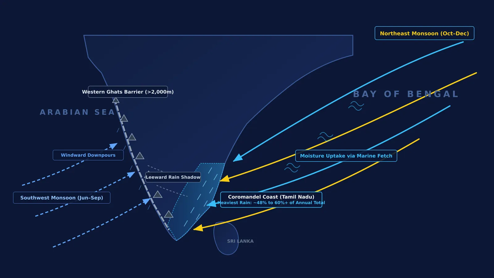
Moist air masses arriving from the Arabian Sea encounter the steep, continuous barrier of the Western Ghats. As this maritime air is forced upward over elevations exceeding 2,000 metres, it expands and cools adiabatically. Water vapour condenses rapidly, dropping torrential rain on the windward slopes of Kerala and coastal Karnataka. By the time the air mass crests the ridge and spills eastward into Tamil Nadu, it has shed most of its moisture. As this dry air descends the leeward slopes, compressive heating lowers its relative humidity and suppresses cloud formation.
Furthermore, the Bay of Bengal branch of the southwest monsoon flows parallel to the Coromandel coastline rather than striking it perpendicularly. Without a relief barrier or thermal low to force vertical uplift, these winds carry their moisture northward toward the Bengal delta without releasing significant rain over Tamil Nadu.
How does the northeast monsoon pick up moisture over the Bay of Bengal?
As autumn arrives, the overhead Sun shifts southward across the equator, reversing peninsular circulation. The intense summer thermal low over northwestern India collapses, replaced by cooler continental temperatures and a regional high-pressure system that directs surface air southwestward in a northeasterly flow.
Meteorologists classify this system as the retreating or northeast monsoon. According to the India Meteorological Department, the seasonal transition begins once the southwest monsoon withdraws south of latitude 15°N, establishing sustained northeasterly winds and coastal rain between October and December. The normal onset over coastal Tamil Nadu occurs around October 20 each year.
These trade winds originate over dry continental interiors, carrying minimal moisture initially. However, their path crosses the warm waters of the Bay of Bengal. High sea surface temperatures drive rapid evaporation, charging the lower atmosphere with water vapour across hundreds of kilometres of open ocean fetch.
This seasonal reversal illustrates the planetary circulation described in George Hadley's model of planetary trade winds, where thermal gradients drive convective circulation cells deflected by the Coriolis force.
Why does the Coromandel coast receive the heaviest rainfall?
When moisture-laden northeasterly winds reach the Coromandel coast, friction with the land decelerates the incoming air, causing horizontal convergence and forced ascent. This mechanical uplift triggers adiabatic cooling, condensing water vapour into dense rainbands and convective clouds.
Long-term records from the India Meteorological Department show that the northeast monsoon delivers approximately 48% of Tamil Nadu's total annual rainfall, with coastal districts such as Chennai, Cuddalore, and Nagapattinam receiving over 60% of their yearly rain during this three-month window.
The season is further intensified by synoptic cyclonic disturbances. As explored in studies of atmospheric pressure differences and cyclic storms, low-pressure depressions regularly form over the southern Andaman Sea. Steered westward by easterly winds, these systems often develop into cyclonic storms that push heavy moisture onshore.
Historical records confirm the interplay between both seasons. In a 100-year observational study from 1877 to 1976, meteorologists Dhar and Rakhecha (1983)111<0109:fnmrot>2.0.co;2) identified an inverse correlation between summer and winter monsoon rainfall in Tamil Nadu, showing that seasons with deficient summer rain often experience higher precipitation during the autumn retreat. On larger scales, climate scientists Zubair and Ropelewski (2006) demonstrated that warm-phase El Niño conditions interact with Walker circulation cells to augment autumn convection across the southern Indian peninsula and Bay of Bengal, a mechanism linked to Gilbert Walker's discovery of the Southern Oscillation.
To help students build intuition for how pressure gradients drive fluid motion and adiabatic cooling, the Fermi Simulation Lab provides interactive simulations for the ideas that are easier to see than to read.
How do India's two monsoon regimes compare?
Comparing the two monsoon systems clarifies why peninsular rainfall is distributed unevenly across the year:
Thermal driver and pressure gradient: Summer heating creates a continental low that pulls moist maritime air northward. Winter continental cooling builds high pressure over northern land, directing dry winds southwestward toward the warmer equatorial ocean.
Wind trajectory and moisture fetch: Summer winds gather water vapour across thousands of kilometres over the Arabian Sea. Winter winds originate dry over land and absorb moisture exclusively while crossing the marine fetch of the Bay of Bengal.
Topographic barrier and rain shadow: The Western Ghats act as an orthogonal barrier to summer winds, forcing orographic downpours in Kerala while casting a dry rain shadow over Tamil Nadu. In autumn, the Coromandel plains face incoming easterly winds directly, without a continuous coastal barrier blocking maritime inflow.
Rainfall distribution: While most Indian states rely almost entirely on summer rains, Tamil Nadu receives nearly half its yearly rainfall between October and December.
Visualizing these atmospheric interactions as an interconnected thermodynamic system helps students master physical geography. The Fermi Concept Library maps every concept in physics, chemistry, biology, mathematics and computing, each with its own lesson and its place in the map, helping learners connect fundamental principles like pressure gradients and adiabatic expansion to real-world phenomena.


