

On this page
Have you ever wondered why morning light breaks in Dong, Arunachal Pradesh, while children in Kutch, Gujarat, are still fast asleep in the dark? The answer lies in the shape of our planet, the way it spins, and the vast distance between India's eastern and western borders.
How wide is India from east to west?
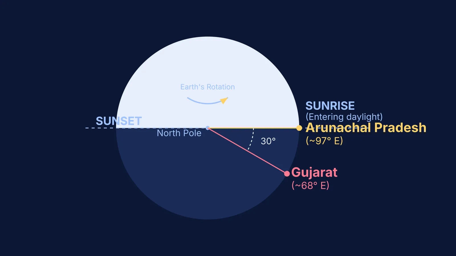
If you trace India's borders on a map, the mainland extends from roughly 68°7'E longitude in Gujarat to 97°25'E longitude in Arunachal Pradesh. This means the country stretches across an extent of approximately 30 degrees of longitude.
Our Home: Earth in Class 8 Curiosity: why life thrives here explains more about Earth's unique physical characteristics, but this 30-degree gap is the key to understanding the country's local solar time. Longitude lines, which run from the North Pole to the South Pole, are used to measure distance east or west of the Prime Meridian. Because the Earth is a sphere, the sun can only illuminate one half of it at any given moment. As the planet turns, different longitudes rotate into the sunlight.
Why does longitude change the sunrise time?
The Earth is a sphere that rotates on its axis from west to east. Because of this continuous rotation, places situated further to the east encounter the sun's rays earlier than places in the west.
If the Earth takes four minutes to rotate through one degree of longitude, we can easily calculate the time lag across India's width. Multiplying the 30-degree span by four minutes gives exactly 120 minutes, or two hours. Therefore, the sun appears above the horizon about two hours earlier in Arunachal Pradesh than it does in Gujarat.
If visualizing the Earth's tilt and rotation on a flat page is difficult, the Fermi Simulation Lab offers interactive tools to explore orbits and rotations, making these spatial concepts much easier to see and understand.
Why do our watches show the same time?
You might wonder why, despite this two-hour difference in solar time, a train schedule or a school bell uses the exact same hour everywhere in the country. To avoid the chaos of setting local clocks in every city, India adopted a single national time zone.
The concept of universal time zones was a historic breakthrough, as explored in Sandford Fleming and the idea of standard time zones. India's standard time is calculated based on the Standard Meridian, which is 82°30'E—a line of longitude that runs right through Mirzapur in Uttar Pradesh. By setting clocks nationwide to match the solar time of this central meridian, the entire country stays in sync. Arunachal Pradesh and Gujarat share the same standard time, even though their skies tell a different story.
The practical effects of a single time zone
While a single time zone makes national logistics much simpler, it creates unique challenges for people living on India's eastern edge. Because the sun rises and sets so early in the Northeast, residents often find themselves starting their workday long after the sun has risen and leaving work in pitch darkness.
To make better use of daylight, tea estates in Assam have historically followed an informal local time known as "Chai Bagan Time" or Tea Garden Time. This local convention is set one hour ahead of Indian Standard Time (UTC+06:30 instead of UTC+05:30). By starting their day earlier, plantation workers can maximize their productivity during daylight hours and finish their shifts before the early sunset.
Over the years, there has been an ongoing debate about whether India should officially adopt two time zones. Proponents argue that an eastern time zone would save significant amounts of electricity by reducing the need for artificial lighting in the evenings. However, the central government has consistently maintained the single time zone to avoid administrative confusion and keep the nation unified on a single clock.
How to calculate time differences anywhere
You can use a simple worked example to calculate the solar time difference between any two cities on Earth. This simple maths exercise helps students see the connection between geometry and the real world, turning an abstract geography fact into a tool they can use anywhere on the globe.
Find the coordinates: Look up the longitudes of both locations. For example, imagine City A is at 75°E and City B is at 80°E.
Calculate the gap: Subtract the smaller longitude from the larger one (80° − 75° = 5°). If they are on opposite sides of the Prime Meridian (one East, one West), you add them instead.
Multiply by 4: Multiply the degree difference by four minutes (5 × 4 = 20).
Apply the time lag: The time difference is 20 minutes. Because the Earth rotates from west to east, the city further east (City B) will see the sunrise 20 minutes earlier than City A.


