

On this page
In 1969, Dr. Vikram Sarabhai and scientist Eknath Chitnis chose Sriharikota—a spindle-shaped barrier island between Pulicat Lake and the Bay of Bengal in Andhra Pradesh—as India's primary spaceport. Operational since 9 October 1971, when a Rohini-125 sounding rocket lifted off, the site is now the Satish Dhawan Space Centre SHAR.
For physics students preparing for exams like JEE Main, Sriharikota illustrates circular motion, reference frames, and relative velocity. Two constraints explain why India launches its heaviest rockets from this island: Earth's eastward spin and the safety corridor of the sea.
Why does Earth's rotation give rockets a free velocity boost?
To place a satellite into Low Earth Orbit (LEO) at an altitude of 300 km, a rocket must reach a horizontal orbital speed of roughly 7,726 m/s. Under orbital mechanics outlined by NASA's Earth Observatory, this speed balances gravity so the craft stays in orbit rather than falling back. Our guide to gravitation and satellite orbital speed derives how centripetal acceleration matches Newtonian gravity: v_orbit = √(GM / r).
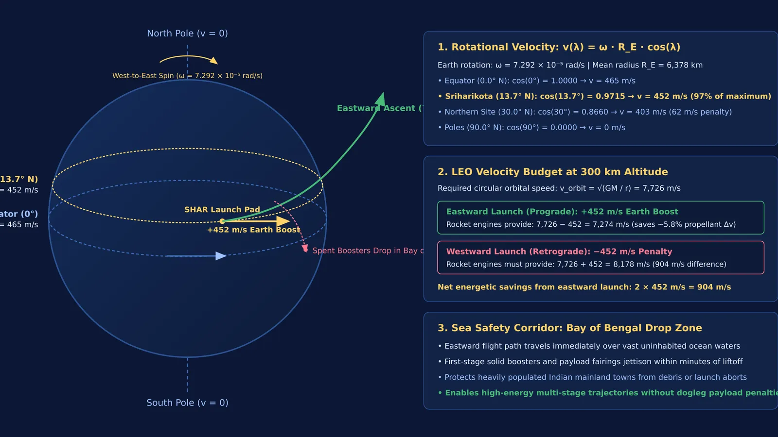
Reaching 7,726 m/s purely with chemical propellants requires substantial fuel. Because Earth completes a sidereal rotation every 86,164 seconds from west to east, points on the surface have an eastward tangential speed. The speed v at latitude λ depends on distance r from Earth's spin axis:
r = R_E × cos(λ)
v(λ) = ω × R_E × cos(λ)
Using Earth's equatorial radius R_E of 6,378 km and angular velocity ω of 7.292 × 10⁻⁵ rad/s, tangential speed at the equator (λ = 0°) is 465 m/s. As the European Space Agency notes for Kourou, this rotation adds roughly 460 m/s of free velocity to an eastward launch.
Sriharikota sits at latitude 13.7° N. Because cos(13.7°) equals 0.9715, the launch pad already moves eastward at:
v_SHAR = 465 m/s × 0.9715 ≈ 452 m/s
Launching eastward into a prograde orbit gives the rocket this 452 m/s boost, providing roughly 5.8% of the 7,726 m/s needed for orbit before firing engines in space. Under the Tsiolkovsky rocket equation, where payload mass drops exponentially with required velocity change, saving 452 m/s frees hundreds of kilograms for satellite payloads.
A westward launch would require cancelling this 452 m/s eastward motion and building 7,726 m/s westward—a 904 m/s penalty. For students visualizing how moving reference frames combine velocity vectors, the Fermi Simulation Lab offers interactive simulations for ideas that are easier to see than to read.
Why must rockets launch eastward over the sea?
Physics favors launching east, but geography dictates pad placement. Multi-stage vehicles like the PSLV and LVM3 shed heavy solid strap-on boosters, first-stage casings, and payload fairings during the first minutes of flight.
Because the rocket flies eastward, spent stages continue along a ballistic arc to the east. As noted by the Smithsonian Institution regarding Cape Canaveral, an open ocean drop zone is vital for range safety. Sriharikota's east-coast location ensures that uninhabited waters of the Bay of Bengal lie beneath the ascent corridor.
If India launched eastward from a west-coast site like Thumba in Kerala, discarded stages would fall across populated mainland areas. Sriharikota isolates hazardous operations and guarantees that launch debris falls harmlessly into the sea.
How does launch latitude affect satellite orbits?
Equatorial proximity is crucial for communication satellites bound for Geostationary Transfer Orbit (GTO). According to ISRO's official centre overview, Satish Dhawan Space Centre's dual launch pads support GSLV and LVM3 missions into these transfer orbits. A geostationary orbit requires an inclination of 0°. Launching due east from latitude λ yields a minimum orbital inclination equal to λ.
Changing orbital inclination in space requires significant propellant:
Δv = 2 × v × sin(Δi / 2)
Launching from Sriharikota at 13.7° N requires only a 13.7° plane change to reach the equator. Launching from 30° N would lose about 14% of Earth's rotational assist and consume extra fuel turning the orbit. Interplanetary missions, as detailed in our guide to Mangalyaan orbit mathematics, used these low-latitude mechanics to reach Mars efficiently.
Polar missions require a different path. For sun-synchronous orbits heading south, launching directly from Sriharikota would cross Sri Lanka. To avoid overflying inhabited land, the PSLV flies a dogleg maneuver, steering southeast over the Bay of Bengal before turning south. To eliminate this fuel-wasting turn, ISRO is building a second spaceport at Kulasekarapattinam in Tamil Nadu with a clear southern corridor.
Rocket trajectories combine kinematics, gravitation, and reference frames. To practice decomposing vectors across frames, the Fermi Problem Library provides worked problems with a step-by-step solver that explains the reasoning rather than printing an answer. Review our breakdown of relative velocity and moving observers to master these principles.


