

On this page
Have you ever looked at the rooftops in your neighbourhood and noticed that every Direct-to-Home (DTH) satellite dish faces exactly the same way? Whether you are in Kerala or Kashmir, the metal dish pulling in your television signal is tilted carefully toward the southern sky.
This is not a coincidence or a quirk of the hardware. The direction your dish points is dictated by the fundamental physics of gravity, satellite orbits and India's position on the globe. Here is why all those antennas look south.
What is a geostationary orbit?
To beam television signals reliably to millions of homes, a satellite must appear to hover completely still in the sky. If the satellite moved across the sky like the International Space Station does, your rooftop dish would need an expensive, noisy motor to track it all day.
A geostationary orbit is a specific circular path where a satellite orbits the Earth at an altitude of 35,786 km directly above the equator. At this exact altitude, the gravitational pull of the Earth provides exactly the right centripetal force to keep the satellite moving at an orbital speed of 3.07 kilometres per second. This results in an orbital period that matches one Earth sidereal day, which is 23 hours, 56 minutes, and 4 seconds.
Because the satellite moves at the exact same angular speed as the Earth rotates, it stays permanently locked over one spot on the equator. If you were to look up at the sky, the satellite would appear completely motionless, day and night. You can set up different orbital velocities and see this period matching for yourself in the Fermi Simulation Lab.
This unique property is what makes satellite television possible. If the satellites were placed in a lower orbit, like the one used by GPS satellites or the Hubble Space Telescope, they would zip across the sky quickly. Your dish would lose the signal constantly unless it was equipped with complex tracking mechanisms.
Why do DTH dishes in India point towards the south?
The answer lies in geography. India's mainland is situated entirely in the Northern Hemisphere, stretching between the latitudes of 8°4' N and 37°6' N.
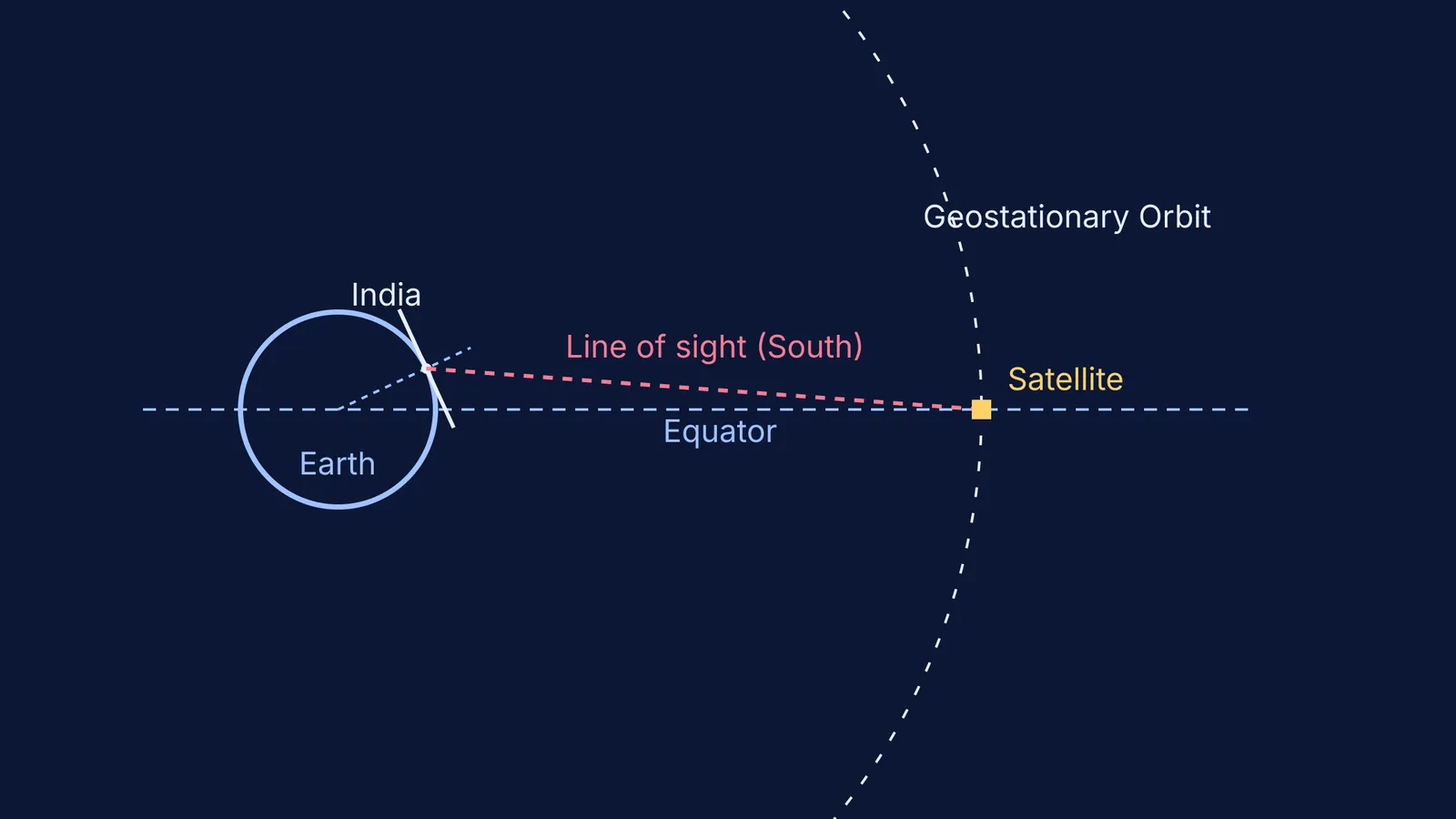
Since geostationary television satellites are permanently parked over the equator, the equator is always geographically south of India. To establish a direct line of sight with a satellite hovering 35,786 km above the Earth, a dish mounted on an Indian rooftop must tilt its face southward. The radio waves carrying your television channels travel in a straight line from the satellite down to your dish. Because the Earth is a sphere, looking "straight" at a satellite over the equator means looking downwards toward the southern horizon.
If you were setting up the same DTH dish in a country in the Southern Hemisphere, such as Australia or South Africa, the geometry would be reversed. The equator would be to your north, so you would have to point the dish toward the northern sky. And if you lived exactly on the equator in a country like Kenya or Ecuador, your dish would point straight up into the sky, directly overhead.
This geometry is a standard application of gravitation and satellite problems often seen in physics exams, connecting abstract orbital mechanics to everyday technology. By understanding the relative positions of the Earth and the satellite, students can calculate the exact angles required for optimal signal reception.
Do they point exactly true south?
While the general direction is always south, the exact alignment—known as the azimuth—depends on the specific satellite your television provider uses. Satellites cannot all be parked in the exact same spot; they are spaced out at different longitudes along the equatorial belt to avoid crashing into each other and to prevent their radio signals from interfering.
For example, if your provider's satellite is parked further east than your city's longitude, your dish will point south and slightly toward the east. A different provider might use a satellite further west, requiring a westward tilt. This is why you might notice that your neighbour's dish, which uses a different DTH brand, points at a slightly different angle than yours.
The elevation angle, or how high the dish points into the sky, also varies by city. If you live in Chennai, which is closer to the equator, the satellite is higher in the sky, so your dish will point more upwards. If you live in Chandigarh, which is much further north, the satellite appears lower on the horizon, requiring a shallower tilt.
How do you set up a dish?
If you ever need to set up or realign a satellite dish yourself, knowing the physics makes the process straightforward.
Find a clear southern view: Ensure there are no tall trees, buildings or walls blocking the southern sky, as satellite signals cannot pass through solid objects.
Determine the azimuth (left/right): Use a compass to find true south, then adjust slightly east or west depending on your provider's specific satellite location.
Set the elevation (up/down): Adjust the upward tilt based on your latitude. If you are in southern India (closer to the equator), the dish will point higher up. If you are in northern India, the dish will point closer to the horizon.
Fine-tune the signal: Make tiny adjustments while checking the signal strength meter on your set-top box. The dish acts as a precise receiver, much like calculating the exact path of a horizontal projectile from a cliff to hit a precise target.
The next time you look at the rooftops, you will know that those dishes are precise mathematical instruments pointing exactly to a narrow ring of satellites in the sky.


