

On this page
Barren Island, a small landmass in the Andaman Sea, holds a unique geographical distinction. Lying approximately 138 kilometres northeast of Port Blair, it is the only confirmed active volcano in the Indian subcontinent (Source)). While much of India sits on a stable continental plate, the Andaman and Nicobar archipelago lies on a turbulent tectonic boundary.
Why is Barren Island India's only active volcano?
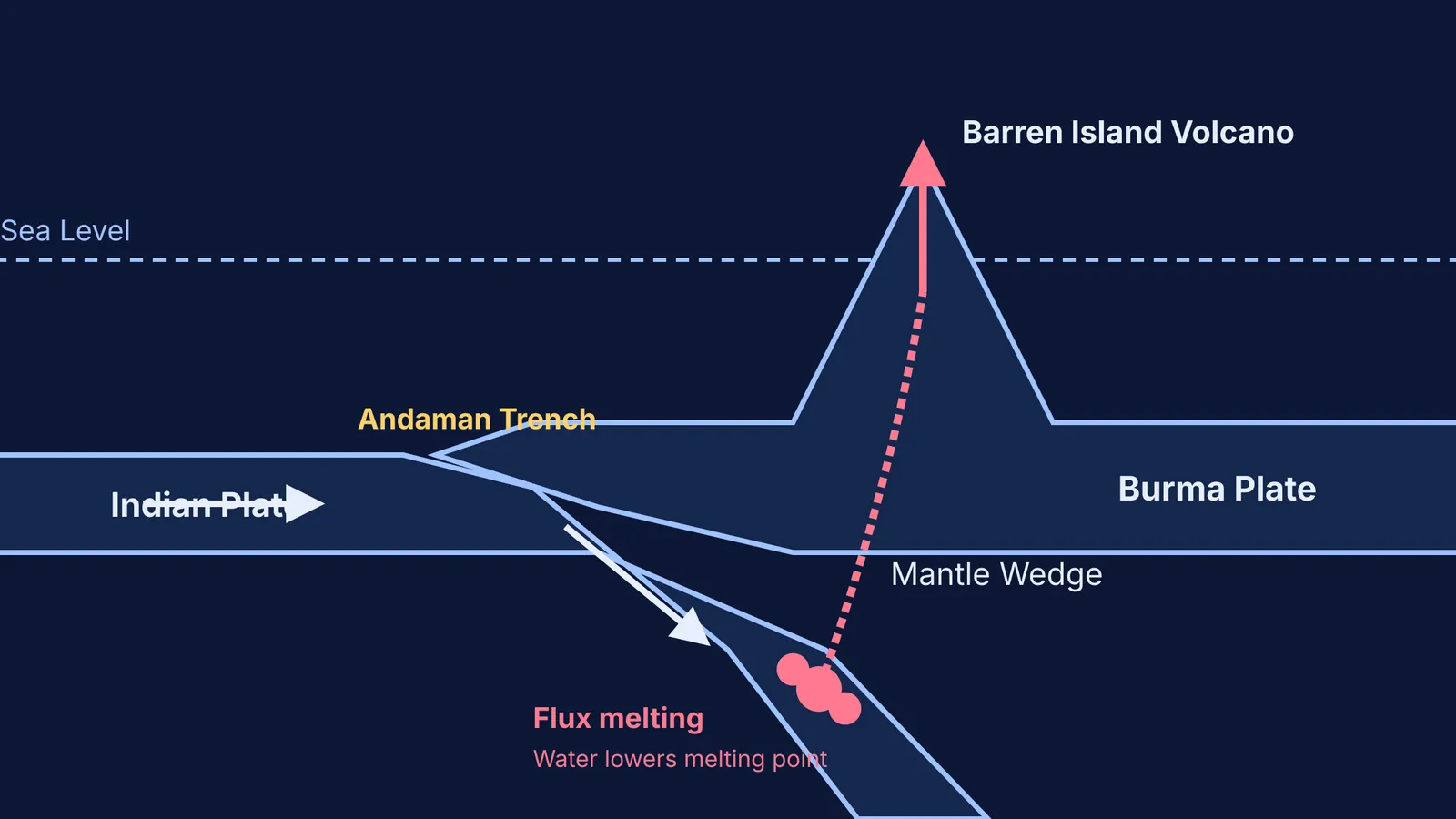
The answer lies in the collision of tectonic plates. India's mainland rests securely on the massive Indian Plate, far from any active plate boundaries. However, Barren Island is located on the much smaller Burma Plate (a microplate). Just west of the island is the Andaman Trench, a deep tectonic boundary where the oceanic crust of the Indian Plate is actively subducting—or sliding—underneath the Burma Plate.
This subduction zone is part of the same massive fault system that created the volcanoes of Indonesia. Because this is the only place in Indian territory where an oceanic plate is actively diving deep into the hot mantle, it is the only place where the specific conditions for generating magma are met.
How does subduction create magma?
You might assume that the friction of the two plates rubbing together creates enough heat to melt rock. In reality, the primary mechanism is a chemical process called flux melting.
As the oceanic Indian Plate plunges into the mantle, it carries water trapped in its minerals. Deep underground, intense heat and pressure force this water out of the descending slab and into the "mantle wedge"—the triangle of hot, solid rock caught between the subducting plate and the overriding Burma Plate.
Just as adding salt lowers the melting point of ice on a winter road, adding water lowers the melting point of the mantle rock. The rock begins to melt, forming a low-potassium basaltic magma. Because this magma is less dense than the surrounding solid rock, it naturally rises, eventually punching through the crust to build the 354-metre-high stratovolcano we see today (Source)).
Visualising the forces at play
In physical chemistry and physics, thermodynamic processes (like those shaping magma) can feel abstract until you map them out. Whether you are converting PV, PT and VT graphs for an ideal gas or modelling convection currents in the mantle, seeing the variables interact makes the theory click.
To build an intuition for how fluids, pressure, and heat behave under extreme conditions, you can use the Fermi Simulation Lab. Instead of just reading about density-driven convection or phase changes, you can adjust the temperature and pressure sliders to watch how the state of a system shifts in real time.
What is the eruptive style of the volcano?
Barren Island is not known for catastrophic, explosive eruptions like Krakatoa. Its eruptions are typically classified as "Strombolian" (Source)). This means they feature regular, mild bursts of expanding gas that throw glowing scoria (cinders) and ash into the air, alongside flows of basaltic lava.
If you are preparing for earth science or physical geography modules in competitive exams, use this three-step framework to analyse any volcano:
Identify the boundary: Is it a divergent boundary (plates pulling apart), a convergent boundary (subduction), or a hot spot?
Determine the magma type: Subduction zones often produce flux-melted mafic or intermediate magmas, which dictate how sticky the lava is.
Predict the eruption: Low-viscosity basaltic magmas generally flow more easily, leading to Strombolian fountaining rather than massive explosive pressure build-ups.
Understanding this chain of cause and effect—from a subducting plate to water release, to flux melting, and finally to a Strombolian eruption—turns Barren Island from an isolated geographical trivia fact into a masterclass in planetary physics.


