

On this page
During the peak of the Indian summer monsoon in July and August, rain does not fall continuously. The season alternates between wet intervals and dry spells lasting several days or weeks. When showers abruptly cease across central and northwestern India without seasonal withdrawal, meteorologists call this a "break in the monsoon". The classical synoptic definition established by K. Ramamurthy in a 1969 India Meteorological Department (IMD) monograph requires the low-pressure monsoon trough to migrate north to the Himalayan foothills and easterly winds to disappear up to 850 hPa (about 1.5 km altitude) for at least 2 consecutive days.
Modern climatologists quantify these swings using high-resolution gridded rainfall records. A landmark study by Rajeevan, Gadgil, and Bhate (2010) defined a break spell as an interval when standardized daily rainfall anomalies over India's core monsoon zone (18°N–28°N, 65°E–88°E) drop below −1.0 standard deviation for at least 3 consecutive days. While 80% of active rain spells end within 3–4 days, about 32% of break spells persist for 7 days or longer (Rajeevan et al., 2010). In 26% of years between 1951 and 2007, India experienced no break spells at all.
A long-term historical analysis across 114 years from 1901 to 2014 by Pai, Sridhar, and Ramesh Kumar (2016) documented 147 break events. During El Niño seasons, India averaged 10.6 break days compared to 7.17 days in La Niña seasons (Pai et al., 2016). Historically, the longest recorded breaks lasted 17 days in 1972 and 16 days in 1979, triggering severe droughts (IMD records).
Why does the monsoon trough shift toward the Himalayas?
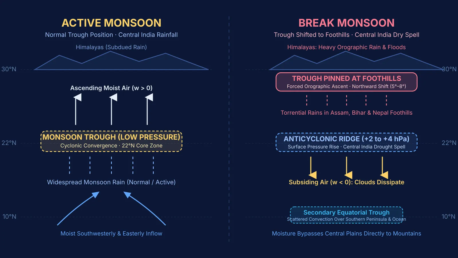
To understand why a break happens, you need to examine the monsoon trough. During normal active conditions, continental heating creates a semi-permanent thermal low over northwestern India and Pakistan. This draws the Inter-Tropical Convergence Zone (ITCZ) northward, establishing an elongated low-pressure trough from Rajasthan to the Bay of Bengal, as described in studies of atmospheric pressure gradients and cyclonic systems. South of this line, moisture-heavy winds sweep from the Arabian Sea; north of it, moist easterlies blow along the Gangetic plain. This convergence creates cyclonic vorticity and drives moist air upward to form rain clouds.
A break occurs when large-scale atmospheric waves disrupt this balance. Research by Ramaswamy (1962) showed that deep mid-latitude westerly troughs in the upper troposphere (between 500 hPa and 200 hPa) can protrude southward over the Tibetan Plateau and northern India. These westerly waves push the subtropical westerly jet stream south, displacing the surface monsoon trough 5° to 8° latitude north to the Himalayan foothills (Ramaswamy, 1962). Simultaneously, cyclogenesis halts in the Bay of Bengal, halting the depressions that normally march across central India.
How do shifting pressure belts silence the rain?
The northward shift fundamentally alters atmospheric vertical motion. In fluid dynamics, mass conservation requires that horizontal air convergence at the surface must escape vertically. When the trough sits over the plains, convergence forces upward motion (w > 0), causing moist air to expand adiabatically, cool past its dew point, and condense. But during a break, surface pressure across central India rises by 2 to 4 hPa above normal, as documented by the India Meteorological Department.
This pressure rise transforms the lower troposphere into an anticyclonic ridge. Instead of rising, air gently sinks toward the ground—a process called subsidence. As air descends, compressive heating raises its temperature and lowers relative humidity. Clouds evaporate, leaving clear skies and high temperatures across central India. This regional redistribution fits into planetary wind systems first mapped in George Hadley's trade winds model and modulated by Gilbert Walker's Southern Oscillation.
Visualising how pressure gradients, Coriolis acceleration, and terrain interact can be challenging on a flat page. The Fermi Simulation Lab provides interactive simulations for the ideas that are easier to see than to read, allowing students to explore fluid flow, thermal convection, and rotating frames of reference. For students looking to master thermodynamics and mechanics, the Fermi Concept Library covers every concept in physics, each with its own lesson and its place in the map.
How can students analyze monsoon active and break spells?
For atmospheric physics problems and competitive exams, you can evaluate the active-break cycle documented by the India Meteorological Department using a four-step framework:
Identify the isobaric trough axis: Check whether the minimum sea-level pressure axis lies across central India near 22°N (active) or has migrated north of 27°N to the Himalayan foothills (break).
Calculate vorticity and vertical motion: Determine if central India exhibits lower-tropospheric cyclonic convergence with vertical ascent (w > 0, driving condensation) or anticyclonic subsidence (w < 0, causing adiabatic compression and dry skies).
Check the orographic boundary condition: When the trough is pinned against the mountains, calculate forced orographic ascent of moist air, which concentrates extreme rainfall over sub-Himalayan West Bengal, Assam, and Nepal.
Watch for equatorial convective revival: A break concludes when a fresh convective cloud band migrates northward from the equatorial Indian Ocean or when a new depression develops over the Bay of Bengal.


