

On this page
When winter sets in over North India, the skies sometimes cloud over, bringing rain to the plains and heavy snow to the Himalayas. These sudden winter showers are the work of Western Disturbances. For Class 9 students studying climate, understanding these weather systems is an excellent way to see global wind patterns in action.
What are Western Disturbances?
A Western Disturbance is an extratropical storm—a low-pressure area that forms outside the tropics—originating in the Mediterranean region. An average of 4 to 5 of these disturbances form during the winter season (Wikipedia).
In the context of the Class 9 Geography syllabus, pressure systems are a fundamental concept. A low-pressure system like a Western Disturbance is essentially a region where the atmospheric pressure at sea level is lower than the surrounding areas. Air naturally flows from high pressure to low pressure, causing winds to spiral inward. Because this air has nowhere to go but up, it rises, cools, and forms clouds. Since they originate in the mid-latitudes—far north of the tropical zones—they are classified as extratropical.
Unlike the summer monsoon, which is driven by intense heating over the Indian subcontinent, these winter storms are created when cold polar air meets warmer, moist air over the Mediterranean Sea, Caspian Sea, and Black Sea. This clash creates a depression in the upper atmosphere. The term "western" means they travel from west to east, and "disturbance" refers to the unstable, low-pressure nature of the air.
How do they bring rain?
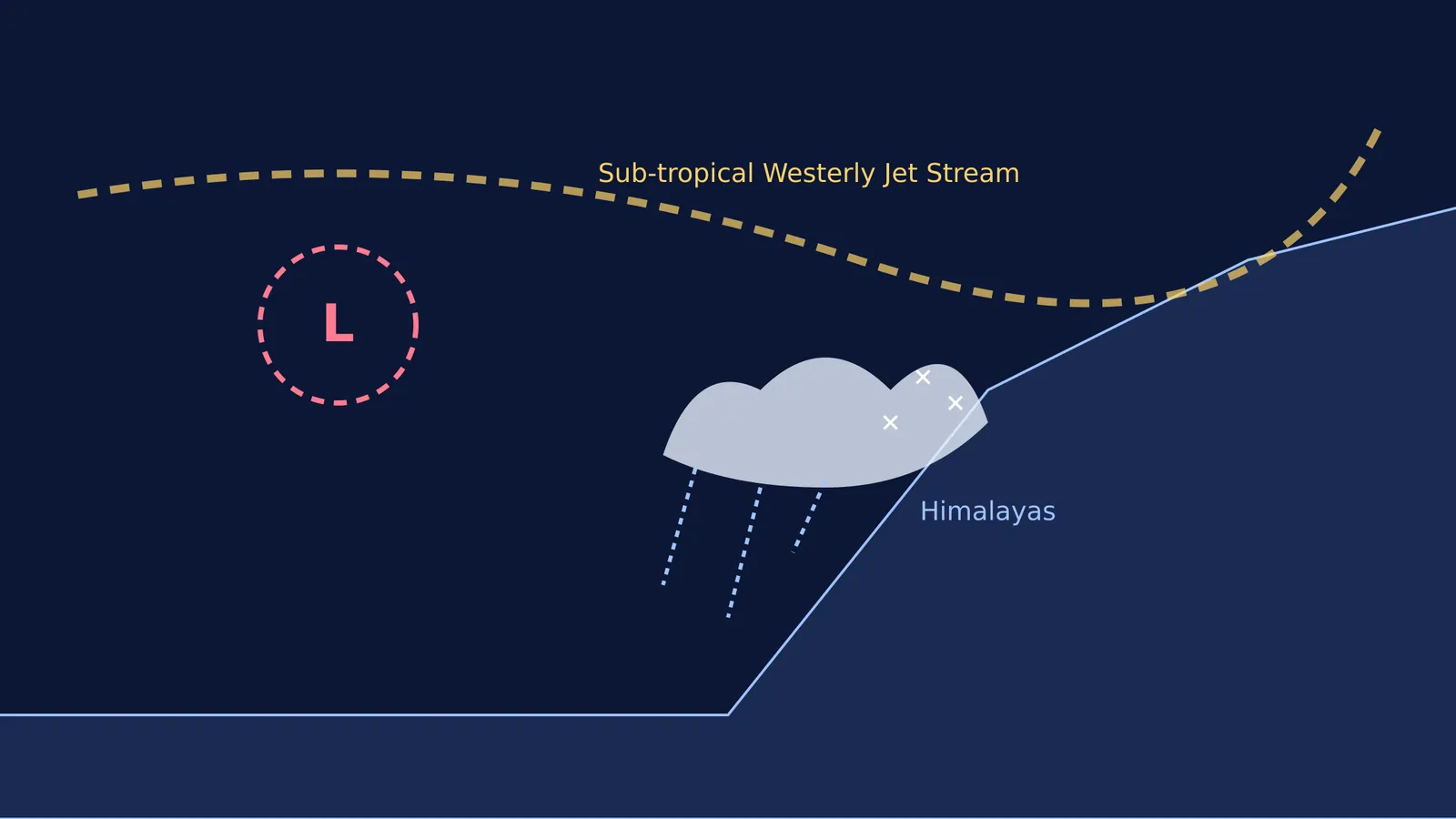
The journey of a Western Disturbance is a perfect example of atmospheric physics. Once formed over the Mediterranean Sea, these storms do not move on their own; they are carried eastward by the sub-tropical westerly jet stream. This jet stream is a high-altitude, fast-moving river of air.
Researchers tracking over 3,000 events across 37 years found that the frequency of these storms in North India is highly sensitive to the southward shift of this jet stream over Eurasia (Quarterly Journal of the Royal Meteorological Society). During winter, the jet stream shifts south of the Himalayas, guiding the storms directly towards the Indian subcontinent.
They travel across West Asia, Iran, Afghanistan, and Pakistan at speeds of up to 43 km/h (Wikipedia). As long as they remain over flat terrain or water, they hold onto their moisture. But when they hit the natural barrier of the Himalayas, the moist air is forced upwards. In physics, this is known as orographic lift. As the air rises to clear the peaks, it expands and cools rapidly. Cold air cannot hold as much moisture as warm air, so the water vapour condenses into heavy snowfall in the mountains and moderate rain in the northwestern plains of India.
Understanding how a high-altitude jet stream carries a storm across continents can be difficult from a textbook alone. The Fermi Simulation Lab has interactive simulations for the ideas that are easier to see than to read.
Why are they important for winter crops?
While the volume of water is small compared to the summer monsoon, its timing is vital. It provides essential moisture for Rabi crops, particularly wheat, which is a staple for India's food security (Wikipedia). Wheat requires cool temperatures and moderate water during its early growing stages. Without this winter rain, the soil in the northern plains would be too dry to sustain a healthy harvest, putting immense pressure on groundwater irrigation.
However, these systems can also bring hazards. When an unusually strong disturbance passes, it can cause severe hailstorms that damage standing crops. Furthermore, once the low-pressure system moves away, it often pulls down freezing air from the snow-capped mountains, leaving behind intense cold waves and dense fog over the Indo-Gangetic plains.
How to study weather systems effectively?
For students preparing for exams, memorising facts about jet streams and Mediterranean storms can feel disconnected and dry. Here is a practical, step-by-step framework for studying any geographic weather pattern actively rather than passively:
Trace the moisture source: Every storm needs fuel. Find where the system gathers its water vapour. For Western Disturbances, it is the Mediterranean and Caspian Seas.
Follow the atmospheric engine: Identify the planetary wind system that drives the storm. Here, it is the sub-tropical westerlies.
Spot the geographic trigger: Look for the physical barrier or temperature change that causes the rain to fall. The towering Himalayas act as a wall that forces the air to rise and precipitate.
Note the human impact: Connect the weather event to agriculture, economy, or daily life. In this case, the winter wheat harvest relies heavily on these rains.
By breaking down a complex climate phenomenon into its source, engine, trigger, and impact, you transform a page of textbook text into a logical sequence of events.
If you are stuck on these concepts while revising the Class 9 climate chapter, Fermi's AI tutor works out what you already know and builds a plan for the session, so you sit down to a clear next step.


