

On this page
When you open a map on your phone, a blue dot appears almost instantly. Your phone does not send a signal into space to ask where it is; it only listens. The Global Positioning System (GPS) is a one-way street, where satellites constantly broadcast their time and position, and your device works out the rest.
Understanding how GPS works is a perfect real-world application of kinematics and geometry, much like finding motion in a plane from r(t). While you might be used to calculating the distance in the nth second of a falling object, GPS deals with constant velocity over vast distances in space.
The speed of light and distance
A GPS receiver calculates its distance from a satellite using a simple formula: distance equals speed multiplied by time.
The satellites broadcast radio waves, which travel at the speed of light—approximately 300,000 kilometres per second (source). The signal contains the exact time it was transmitted and the position of the satellite at that moment. When your phone receives it, it compares that timestamp to its own internal clock to find the time of flight.
Because the speed of light is so vast, tiny timing errors matter. A clock error of just 1 microsecond (0.000001 seconds) would put your calculated position off by 300 metres.
How does GPS trilateration work?
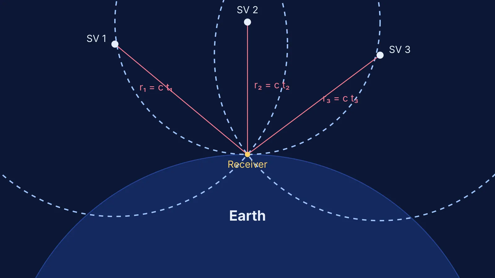
To find a point in three-dimensional space, the receiver uses trilateration—finding where multiple spheres intersect.
If you know your exact distance from satellite A, you are somewhere on the surface of a giant sphere with that radius. If you add satellite B, the two spheres intersect to form a two-dimensional circle in space. Adding a third satellite narrows that circle down to just two points. One of these points is usually moving impossibly fast in deep space or is deep underground, so your phone discards it and takes the other as your location.
To visualise intersecting shapes and understand 3D geometries, static textbook diagrams can be limiting. The Fermi Simulation Lab provides interactive simulations for ideas that are easier to see than to read.
Why is a fourth satellite needed?
If three satellites give a 3D position, why does a standard fix require a minimum of 4 satellites to compute your location (source)? The answer lies in your phone's clock.
GPS satellites carry highly precise atomic clocks, but your smartphone uses a cheap, less accurate quartz clock. If the phone's clock is off by a fraction of a second, every distance calculation will be wrong by the exact same amount.
A fourth satellite provides a fourth intersecting sphere. If your phone's clock is perfectly aligned with the satellites, all four spheres will meet perfectly at a single point. If they do not, the receiver mathematically adjusts its own time until they do. By doing this, your phone effectively synchronises itself with the atomic clocks in space, giving it the exact time and allowing it to lock onto your position. Modern smartphones can achieve an accuracy of about 4.9 metres under clear skies (source).
How does relativity affect GPS?
The physics of GPS gets even stranger when you factor in Albert Einstein's theory of relativity. Time does not tick at the same rate everywhere.
Special relativity: Because the satellites are moving fast (roughly 3.9 km/s), time for them slows down relative to an observer on Earth. This effect slows the satellite clocks by about 7.2 microseconds per day (source).
General relativity: The satellites orbit at an altitude of approximately 20,180 kilometres. Gravity is weaker there than on the Earth's surface. According to general relativity, clocks deeper in a gravitational well tick slower. Being higher up in a weaker gravitational field speeds the satellite clocks up by about 45.8 microseconds per day (source).
When you combine these two effects, the satellite clocks gain a net 38.6 microseconds per day relative to clocks on the ground (source).
If engineers ignored this, the time error would compound, resulting in a positioning error of roughly 11.4 kilometres per day (source). To fix this, the clocks on the satellites are intentionally set to run slightly slower before they launch, perfectly balancing the effects of relativity once they reach orbit.
The next time you see that blue dot on your map, remember: your phone is not just solving geometry; it is compensating for the speed of light and the warping of space-time.


